IMAGES TAKEN NEAR TO
Murillo Road, LONDON, SE13 5QF
Introduction
This page details the photographs taken nearby to Murillo Road, SE13 5QF by members of the Geograph project.
The Geograph project started in 2005 with the aim of publishing, organising and preserving representative images for every square kilometre of Great Britain, Ireland and the Isle of Man.

There are currently over 7.5m images from over14,400 individuals and you can help contribute to the project by visiting https://www.geograph.org.uk
Image Map
Images are licensed for reuse under creativecommons.org/licenses/by-sa/2.0
Notes
- Clicking on the map will re-center to the selected point.
- The higher the marker number, the further away the image location is from the centre of the postcode.
Image Listing (136 Images Found)
Images are licensed for reuse under creativecommons.org/licenses/by-sa/2.0
Image
Details
Distance
5
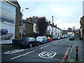
Shops and flats in Lee High Road, SE13
Shows the location of Image
Image: © Mike Quinn
Taken: 30 Jul 2010
0.10 miles
7
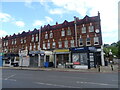
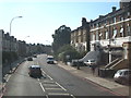
Manor Park Parade
Shops on Lee High Road (A20).
Image: © JThomas
Taken: 24 Jun 2022
0.10 miles
8
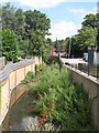
The Quaggy River south of Weardale Road, SE13 (2)
Image: © Mike Quinn
Taken: 30 Jul 2010
0.10 miles
9
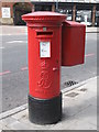
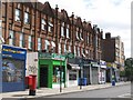
Edward VII postbox, Lee High Road / Weardale Road, SE13
Image: © Mike Quinn
Taken: 30 Jul 2010
0.11 miles
10
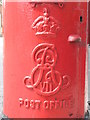
Edward VII postbox, Lee High Road / Weardale Road, SE13 - royal cipher
See Image
Image: © Mike Quinn
Taken: 30 Jul 2010
0.11 miles