IMAGES TAKEN NEAR TO
Lewisham High Street, LONDON, SE13 5LN
Introduction
This page details the photographs taken nearby to Lewisham High Street, SE13 5LN by members of the Geograph project.
The Geograph project started in 2005 with the aim of publishing, organising and preserving representative images for every square kilometre of Great Britain, Ireland and the Isle of Man.

There are currently over 7.5m images from over14,400 individuals and you can help contribute to the project by visiting https://www.geograph.org.uk
Image Map
Images are licensed for reuse under creativecommons.org/licenses/by-sa/2.0
Notes
- Clicking on the map will re-center to the selected point.
- The higher the marker number, the further away the image location is from the centre of the postcode.
Image Listing (270 Images Found)
Images are licensed for reuse under creativecommons.org/licenses/by-sa/2.0
Image
Details
Distance
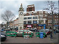
1
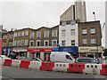
Shops at the north end of Lewisham High Street
These shops might not survive the wholesale redevelopment of the areas between the railway station and town centre (evidenced by the traffic barriers in the foreground). As of 2015 they comprised (right to left) a textile shop, employment agency, betting shop, Chelsea Building Society and Halifax bank.
Image: © Stephen Craven
Taken: 23 May 2015
0.02 miles
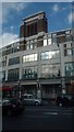
2
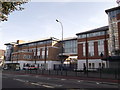
Lewisham Metropolitan Police Station (2)
Very large police station on Lewisham High Street.
Image: © David Anstiss
Taken: 25 Sep 2011
0.03 miles
4
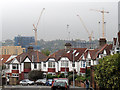
Redeveloping Lewisham
The tower cranes seen here from the vantage point of Hilly Fields are invovled in rebuilding the northern end of the town centre.
The road in the foreground is Vicars Hill.
Image: © Stephen Craven
Taken: 13 Oct 2011
0.04 miles
5
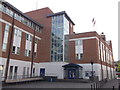
Lewisham Metropolitan Police Station
Very large police station on Lewisham High Street.
Image: © David Anstiss
Taken: 25 Sep 2011
0.04 miles
6
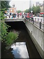
The Quaggy River by Granville Grove, SE13 (6)
Image: © Mike Quinn
Taken: 30 Jul 2010
0.05 miles
7
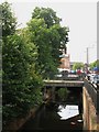
The Quaggy River by Granville Grove, SE13 (3)
Image: © Mike Quinn
Taken: 30 Jul 2010
0.06 miles
8
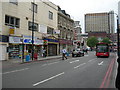
Lee High Road SE13 (2)
Looking towards Lewisham centre. Across the road is the Beauty Shop and the money transfer facility referred to in the 1st photo in this series (that looks in the opposite direction). Link here http://www.geograph.org.uk/photo/192760
Image: © Danny P Robinson
Taken: 27 Jun 2006
0.06 miles
9
Lewisham High Street near Clock Tower
Image: © Danny P Robinson
Taken: 25 Feb 2007
0.06 miles
10
Inter-war building, Lewisham High Street
The dates on this building seem to suggest that it was built in 1933 for a firm founded in 1868 (exactly 75 years before), or something along those lines. Along the top of the frontage are art deco reliefs of different means of transport: see Image I have no idea of its former function, but it has the look of a department store: it clearly now comprises a large space made use of for various different functions, its occupants having changed since it was photographed in 2007 (Image).
Image: © Christopher Hilton
Taken: 27 Aug 2015
0.06 miles