IMAGES TAKEN NEAR TO
Dacre Place, LONDON, SE13 5DJ
Introduction
This page details the photographs taken nearby to Dacre Place, SE13 5DJ by members of the Geograph project.
The Geograph project started in 2005 with the aim of publishing, organising and preserving representative images for every square kilometre of Great Britain, Ireland and the Isle of Man.

There are currently over 7.5m images from over14,400 individuals and you can help contribute to the project by visiting https://www.geograph.org.uk
Image Map
Images are licensed for reuse under creativecommons.org/licenses/by-sa/2.0
Notes
- Clicking on the map will re-center to the selected point.
- The higher the marker number, the further away the image location is from the centre of the postcode.
Image Listing (114 Images Found)
Images are licensed for reuse under creativecommons.org/licenses/by-sa/2.0
Image
Details
Distance
5
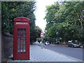
Phone box near Blackheath
A public telephone on Lee Terrace near Blackheath in South East London.
Image: © Malc McDonald
Taken: 11 Aug 2011
0.06 miles
6
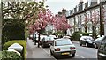
Quentin Road, London SE13
Spring 2002 Taken looking north towards Lee Terrace
Image: © Steve Haywood
Taken: 14 Apr 2002
0.07 miles
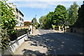
10
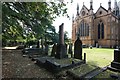
St Margaret, Brandram Road - Churchyard
Image: © John Salmon
Taken: 22 Sep 2012
0.07 miles