IMAGES TAKEN NEAR TO
Boyne Road, LONDON, SE13 5AN
Introduction
This page details the photographs taken nearby to Boyne Road, SE13 5AN by members of the Geograph project.
The Geograph project started in 2005 with the aim of publishing, organising and preserving representative images for every square kilometre of Great Britain, Ireland and the Isle of Man.

There are currently over 7.5m images from over14,400 individuals and you can help contribute to the project by visiting https://www.geograph.org.uk
Image Map
Images are licensed for reuse under creativecommons.org/licenses/by-sa/2.0
Notes
- Clicking on the map will re-center to the selected point.
- The higher the marker number, the further away the image location is from the centre of the postcode.
Image Listing (109 Images Found)
Images are licensed for reuse under creativecommons.org/licenses/by-sa/2.0
Image
Details
Distance
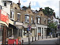
2
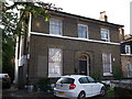
18 Belmont Hill, Lewisham
Grade II listed house on the road. Part of a row of 5 listed houses.
See http://www.britishlistedbuildings.co.uk/en-203225-10-18-lewisham for more details.
Image: © David Anstiss
Taken: 25 Sep 2011
0.15 miles
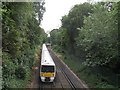
4
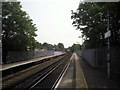
Lewisham station
The original part of Lewisham station opened in 1849, on the North Kent Line which by-passed Greenwich because the Royal Observatory did not want their sensitive instruments disturbed by trains. This view looks along that original line towards Blackheath. A Networker train is just leaving on its way to Blackheath.
Image: © Marathon
Taken: 6 May 2011
0.16 miles
5
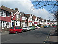
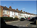
Belmont Hill, SE13
This is the main route from Lewisham to Blackheath. You do not need to go far along this road to leave the bustle of Lewisham behind.
Image: © Danny P Robinson
Taken: 25 Mar 2007
0.16 miles
6
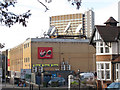
Virgin Media installation, Lewisham
An array of satellite dishes on the roof of a bowling alley. The tall building in the background is "Lewisham House" Image
Image: © Stephen Craven
Taken: 13 Jan 2012
0.16 miles
8
Train between Blackheath and Lewisham
An "electrostar" train heading towards London Charing Cross, seen from the bridge on St Joseph's Vale Image
Image: © Stephen Craven
Taken: 10 Jul 2015
0.17 miles
10
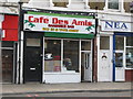
Caf? des Amis, Lee High Road, SE13
The location of this café is shown in Image
Image: © Mike Quinn
Taken: 30 Jul 2010
0.18 miles