IMAGES TAKEN NEAR TO
Shad Thames, LONDON, SE1 2YQ
Introduction
This page details the photographs taken nearby to Shad Thames, SE1 2YQ by members of the Geograph project.
The Geograph project started in 2005 with the aim of publishing, organising and preserving representative images for every square kilometre of Great Britain, Ireland and the Isle of Man.

There are currently over 7.5m images from over14,400 individuals and you can help contribute to the project by visiting https://www.geograph.org.uk
Image Map
Images are licensed for reuse under creativecommons.org/licenses/by-sa/2.0
Notes
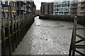
- Clicking on the map will re-center to the selected point.
- The higher the marker number, the further away the image location is from the centre of the postcode.
Image Listing (887 Images Found)
Images are licensed for reuse under creativecommons.org/licenses/by-sa/2.0
Image
Details
Distance
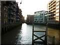
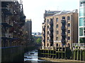
2
St Saviour's Dock, Bermondsey
Seen from the Thames Path.
Image: © David Purchase
Taken: 15 Sep 2012
0.01 miles
3
Crossing over St Saviours Dock on the Thames river path
Image: © Ian S
Taken: 9 Dec 2010
0.01 miles
4
Java Wharf
Former warehouses at Shad Thames, now converted into desirable riverside apartments. They retain the balconies.
Image: © Colin Smith
Taken: 2 Sep 2011
0.01 miles
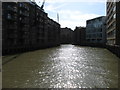
5
St Saviour's Dock in Bermondsey
St Saviour's Dock is a small dock on the south bank of the River Thames, London, 420 metres east of Tower Bridge.
Image: © Steve Daniels
Taken: 25 Jun 2012
0.02 miles
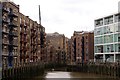
6
St Saviour's dock, Bermondsey
The dock is essentially the tidal creek at the mouth of the River Neckinger, which now runs underground for most of its course through South London. The various warehouses either side of the dock are now all listed buildings and mostly in residential use.
Image: © Stephen Craven
Taken: 8 Mar 2015
0.02 miles
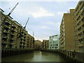
7
St Saviour's Dock
Charles Dickens set portions of his novel Oliver Twist in this area, at a time when it was an area of notorious poverty known as Jacob's Island. He set Bill Sikes's den in buildings adjacent to St Saviour's Dock. It is here that Sikes falls from a roof and dies in the mud, probably of St Saviour's Dock.
The view from the other end can be seen at https://www.geograph.org.uk/photo/6000597
Image: © Marathon
Taken: 9 Oct 2019
0.02 miles
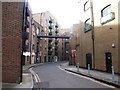
8
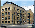
13-15 Shad Thames
Despite late C20th depradations, the street retains a sense of its industrial past with many surviving warehouses, now mostly converted to flats.
On the corner of Gainsford Street is Coriander Court.
Further along (right) is Anise Warehouse, early-mid C19th. Grade II listed.
Image: © Stephen Richards
Taken: 26 May 2013
0.02 miles
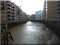
9
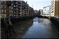
St Saviour's Dock
Low tide in St Saviour's Dock which is situated a few hundred metres to the east of Tower Bridge.
Image: © Philip Halling
Taken: 1 Oct 2011
0.02 miles