IMAGES TAKEN NEAR TO
Tooley Street, LONDON, SE1 2NS
Introduction
This page details the photographs taken nearby to Tooley Street, SE1 2NS by members of the Geograph project.
The Geograph project started in 2005 with the aim of publishing, organising and preserving representative images for every square kilometre of Great Britain, Ireland and the Isle of Man.

There are currently over 7.5m images from over14,400 individuals and you can help contribute to the project by visiting https://www.geograph.org.uk
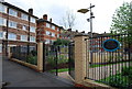
Image Map
Images are licensed for reuse under creativecommons.org/licenses/by-sa/2.0
Notes
- Clicking on the map will re-center to the selected point.
- The higher the marker number, the further away the image location is from the centre of the postcode.
Image Listing (873 Images Found)
Images are licensed for reuse under creativecommons.org/licenses/by-sa/2.0
Image
Details
Distance
1
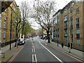
A200 Tooley Street
Towards London Bridge.
Image: © Robin Webster
Taken: 6 Apr 2019
0.01 miles
4
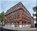
Boss House, Tooley Street
Big former warehouse, early C20th by the look of it, now converted to flats.
Image: © Stephen Richards
Taken: 26 May 2013
0.02 miles
5
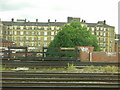
Victorian flats, Bermondsey, from the train
These are the backs of a long block of flats on the south side of Tooley Street.
Image: © Christopher Hilton
Taken: 7 Jun 2011
0.03 miles
6
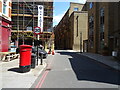
Three Oak Lane, London SE1
Showing position of postbox No. SE1 79 / postbox No. SE1 179.
See Image] for postbox.
Image: © JThomas
Taken: 20 Jun 2022
0.03 miles
7
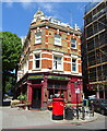
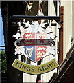
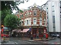
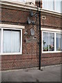
The Kings Arms
On Tooley Street (A200).
See Image] for pub sign.
Image: © JThomas
Taken: 20 Jun 2022
0.03 miles
8
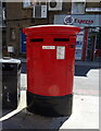
Double aperture Elizabeth II postbox on Tooley Street
Postbox No. SE1 79 and Postbox No. SE1 179.
See Image] for context.
Image: © JThomas
Taken: 20 Jun 2022
0.03 miles
10
Air Raid Shelter Sign, Druid Street
One of several air raid shelter signs painted on the walls of the St John's Estate, Druid Street. The shelter (a railway arch on Druid Street) was hit by a bomb on October 25th 1940, killing 77 people.
Image: © Chris Lewis
Taken: 12 Jan 2010
0.03 miles