IMAGES TAKEN NEAR TO
Wolseley Street, LONDON, SE1 2BN
Introduction
This page details the photographs taken nearby to Wolseley Street, SE1 2BN by members of the Geograph project.
The Geograph project started in 2005 with the aim of publishing, organising and preserving representative images for every square kilometre of Great Britain, Ireland and the Isle of Man.

There are currently over 7.5m images from over14,400 individuals and you can help contribute to the project by visiting https://www.geograph.org.uk
Image Map (Loading...)


Getting Data...Please wait
Leaflet Map data © OpenStreetMap
Images are licensed for reuse under creativecommons.org/licenses/by-sa/2.0
Notes
- Clicking on the map will re-center to the selected point.
- The higher the marker number, the further away the image location is from the centre of the postcode.
Image Listing (542 Images Found)
Images are licensed for reuse under creativecommons.org/licenses/by-sa/2.0
Image
Details
Distance
1
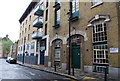
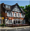
Dombey House
Located on Wolseley Street, the house forms part of the Dickens Estate on which all the houses are named after characters from the stories of Charles Dickens.
Image: © Martin Addison
Taken: 22 Oct 2010
0.02 miles
2
Bermondsey fire station
Bermondsey Fire Station on Dockhead
Image: © Stephen Craven
Taken: 4 Jul 2006
0.04 miles
3
Bermondsey : "The Ship Aground" public house
Image: © Jim Osley
Taken: 19 Jul 2021
0.04 miles
6
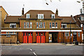
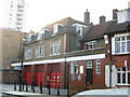
Dockhead Fire Station
Located on Wolseley Street, this fire station still carries the crest of London County Council and its LCC lettering above the doors. The London County Council came into existence in 1889 and survived until 1965 when it was succeeded by the Greater London Council. The fire station itself was used as the fictional Blackwall fire station in the early series of the TV program London's Burning. It currently houses a single pump-ladder appliance. Built in the 1920's, government permission has been given for its demolition and replacement with a modern station in 2012.
Image: © Martin Addison
Taken: 22 Oct 2010
0.06 miles
7
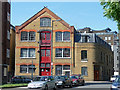
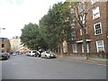
23 Jacob Street
Former warehouse, its loading bays given a nice coat of red paint. Now flats.
The modest adjoining building, no.67 George Row, is apparently a former chainsmith's and light engineering workshop dating from c1840. Grade II listed.
Image: © Stephen Richards
Taken: 27 May 2013
0.06 miles
8
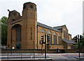
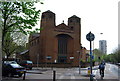
Most Holy Trinity Church
Located in the v created by the junction of Jamaica Road with Dockhead, this Roman Catholic church was designed by HS Goodhart-Rendel and completed in 1959. It replaced a previous church on this site that had been destroyed by wartime bombing.
Image: © Martin Addison
Taken: 22 Oct 2010
0.07 miles