IMAGES TAKEN NEAR TO
Mill Street, LONDON, SE1 2BD
Introduction
This page details the photographs taken nearby to Mill Street, SE1 2BD by members of the Geograph project.
The Geograph project started in 2005 with the aim of publishing, organising and preserving representative images for every square kilometre of Great Britain, Ireland and the Isle of Man.

There are currently over 7.5m images from over14,400 individuals and you can help contribute to the project by visiting https://www.geograph.org.uk
Image Map
Images are licensed for reuse under creativecommons.org/licenses/by-sa/2.0
Notes
- Clicking on the map will re-center to the selected point.
- The higher the marker number, the further away the image location is from the centre of the postcode.
Image Listing (667 Images Found)
Images are licensed for reuse under creativecommons.org/licenses/by-sa/2.0
Image
Details
Distance
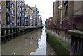
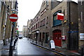
3
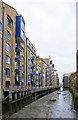
St Saviour's Dock
Charles Dickens set portions of his novel Oliver Twist in this area, at a time when it was an area of notorious poverty known as Jacob's Island. He set Bill Sikes's den in buildings adjacent to St Saviour's Dock. It is here that Sikes falls from a roof and dies in the mud, probably of St Saviour's Dock.
The view from the other end at the mouth of St Saviour's Dock can be seen at https://www.geograph.org.uk/photo/6294916
Image: © Marathon
Taken: 10 Dec 2018
0.02 miles
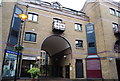
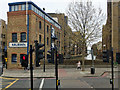
4
View up Mill Street from Jamaica Road
Looking north-northeast.
Image: © Robert Lamb
Taken: 27 Jan 2019
0.02 miles
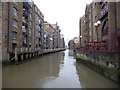
5
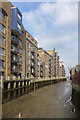
St. Saviours Dock
Lined with the wharves that handled London's tea, coffee and spice trade, St. Saviours Dock is the inlet where the subterranean River Neckinger joins the Thames, though I couldn't see exactly where (probably beneath my feet). The dock was given its name by Cluniac Monks from Bermondsey Abbey. The Thames, visible between the buildings in the distance, is tidal and water in the dock rises by around 4 metres and, when there is a tidal surge, comes very close to the lower windows of the wharves.
Image: © Martin Addison
Taken: 22 Oct 2010
0.02 miles
6
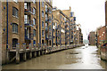
St Saviour's Dock
A few hundred metres of tidal mud is all that remains of one of the most lost of London's lost rivers, the Neckinger. https://en.wikipedia.org/wiki/River_Neckinger
Most of the river is now diverted into sewers and only storm flow ever discharges here. The old warehouses are converted into apartments whose residents might not recognise the Morning Chronicle's description of the locality in 1849 as "The very capital of cholera" and "The Venice of drains". In Dickens' novel, Oliver Twist a branch of the Neckinger is given the name Folly Ditch and is the place where the book's Bill Sikes meets his death.
Image: © Des Blenkinsopp
Taken: 21 Feb 2018
0.02 miles
7
St.Saviour's Dock
Former wharves on St.Saviour's Dock from Jamaica Road
Image: © Richard Croft
Taken: 16 Aug 2011
0.03 miles
8
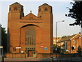
Holy Trinity church
The west end of Holy Trinity (Roman Catholic) church on Dockhead. Designed by H.S.Goodhart-Rendel and built 1957-1960. Listed Grade II.
Image: © Stephen Craven
Taken: 4 Jul 2006
0.03 miles
10
St Saviour's Dock, Bermondsey
A tidal dock, now disused, the mouth of the River Neckinger, which otherwise is culverted underground.
Image: © Robin Webster
Taken: 6 Apr 2019
0.03 miles