IMAGES TAKEN NEAR TO
Mill Street, LONDON, SE1 2BA
Introduction
This page details the photographs taken nearby to Mill Street, SE1 2BA by members of the Geograph project.
The Geograph project started in 2005 with the aim of publishing, organising and preserving representative images for every square kilometre of Great Britain, Ireland and the Isle of Man.

There are currently over 7.5m images from over14,400 individuals and you can help contribute to the project by visiting https://www.geograph.org.uk
Image Map
Images are licensed for reuse under creativecommons.org/licenses/by-sa/2.0
Notes
- Clicking on the map will re-center to the selected point.
- The higher the marker number, the further away the image location is from the centre of the postcode.
Image Listing (635 Images Found)
Images are licensed for reuse under creativecommons.org/licenses/by-sa/2.0
Image
Details
Distance
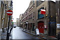
2
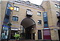
Mill Street (1)
Another atmospheric street lined with tall warehouses.
Those on the left hand side date from the second half of the C19th. All grade II listed.
Image: © Stephen Richards
Taken: 26 May 2013
0.01 miles
4
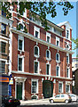
41-43 Dockhead
Aka the Italian Building. Most jolly, rather Baroque with quirky details such as the gabled ends. Was the top floor added later?
Image: © Stephen Richards
Taken: 27 May 2013
0.03 miles
6
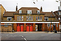
Dockhead Fire Station
Located on Wolseley Street, this fire station still carries the crest of London County Council and its LCC lettering above the doors. The London County Council came into existence in 1889 and survived until 1965 when it was succeeded by the Greater London Council. The fire station itself was used as the fictional Blackwall fire station in the early series of the TV program London's Burning. It currently houses a single pump-ladder appliance. Built in the 1920's, government permission has been given for its demolition and replacement with a modern station in 2012.
Image: © Martin Addison
Taken: 22 Oct 2010
0.03 miles
7
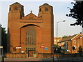
Holy Trinity church
The west end of Holy Trinity (Roman Catholic) church on Dockhead. Designed by H.S.Goodhart-Rendel and built 1957-1960. Listed Grade II.
Image: © Stephen Craven
Taken: 4 Jul 2006
0.04 miles

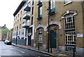
9
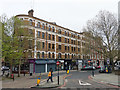
Tower Bridge Buildings, Dockhead, SE1
A hopeful name, I have some doubt whether even the top floor can see much of the bridge. The flats are accessed from behind, Mill Street, and use that address.
Image: © Robin Webster
Taken: 6 Apr 2019
0.04 miles
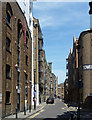
10
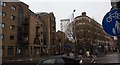
View up Mill Street from Jamaica Road
Looking north-northeast.
Image: © Robert Lamb
Taken: 27 Jan 2019
0.04 miles