IMAGES TAKEN NEAR TO
Chinbrook Road, LONDON, SE12 9TF
Introduction
This page details the photographs taken nearby to Chinbrook Road, SE12 9TF by members of the Geograph project.
The Geograph project started in 2005 with the aim of publishing, organising and preserving representative images for every square kilometre of Great Britain, Ireland and the Isle of Man.

There are currently over 7.5m images from over14,400 individuals and you can help contribute to the project by visiting https://www.geograph.org.uk
Image Map
Images are licensed for reuse under creativecommons.org/licenses/by-sa/2.0
Notes
- Clicking on the map will re-center to the selected point.
- The higher the marker number, the further away the image location is from the centre of the postcode.
Image Listing (117 Images Found)
Images are licensed for reuse under creativecommons.org/licenses/by-sa/2.0
Image
Details
Distance
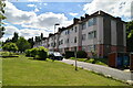
1
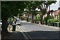
Trees 1, Pavement 0
Substantial trees occupy almost the entire width of the pavement on the north side of Chinbrook Road.
Image: © David Martin
Taken: 15 Feb 2022
0.02 miles
6
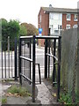
Mind your head!
Best to use the kissing gate if you're more than about 4ft tall.
Image: © Mike Quinn
Taken: 28 Sep 2010
0.05 miles
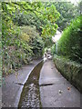
7
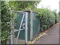
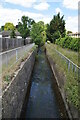
Grove Park (Chinbrook Meadows) Gauging Station
On Image - marked by the green railings on the left bank of the stream (centre).
Image: © Mike Quinn
Taken: 28 Sep 2010
0.05 miles
8
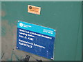
Sign on the Grove Park (Chinbrook Meadows) Gauging Station
See Image
Image: © Mike Quinn
Taken: 28 Sep 2010
0.05 miles
9
The Quaggy River south of Chinbrook Road, SE12 (2)
Image: © Mike Quinn
Taken: 28 Sep 2010
0.05 miles