IMAGES TAKEN NEAR TO
Dyneley Road, LONDON, SE12 9RT
Introduction
This page details the photographs taken nearby to Dyneley Road, SE12 9RT by members of the Geograph project.
The Geograph project started in 2005 with the aim of publishing, organising and preserving representative images for every square kilometre of Great Britain, Ireland and the Isle of Man.

There are currently over 7.5m images from over14,400 individuals and you can help contribute to the project by visiting https://www.geograph.org.uk
Image Map
Images are licensed for reuse under creativecommons.org/licenses/by-sa/2.0
Notes
- Clicking on the map will re-center to the selected point.
- The higher the marker number, the further away the image location is from the centre of the postcode.
Image Listing (77 Images Found)
Images are licensed for reuse under creativecommons.org/licenses/by-sa/2.0
Image
Details
Distance
1
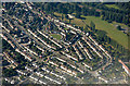
Grove Park from the air
Chinbrook Meadows park is to the top right.
Image: © Thomas Nugent
Taken: 26 Aug 2019
0.03 miles
7
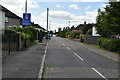
Grove Park Road, Mottingham SE12
Looking northeast. Marvels Lane leads left and right from this crossroads; the B226 Grove Park Road is ahead, with B226 Chinbrook Road behind the camera and to the left.
Image: © Philip Talmage
Taken: 4 Nov 2005
0.11 miles
10
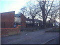
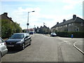
Grove Park youth club and houses on Grove Park Road
Image: © David Howard
Taken: 11 Mar 2012
0.13 miles