IMAGES TAKEN NEAR TO
Balder Rise, LONDON, SE12 9PX
Introduction
This page details the photographs taken nearby to Balder Rise, SE12 9PX by members of the Geograph project.
The Geograph project started in 2005 with the aim of publishing, organising and preserving representative images for every square kilometre of Great Britain, Ireland and the Isle of Man.

There are currently over 7.5m images from over14,400 individuals and you can help contribute to the project by visiting https://www.geograph.org.uk
Image Map
Images are licensed for reuse under creativecommons.org/licenses/by-sa/2.0
Notes
- Clicking on the map will re-center to the selected point.
- The higher the marker number, the further away the image location is from the centre of the postcode.
Image Listing (115 Images Found)
Images are licensed for reuse under creativecommons.org/licenses/by-sa/2.0
Image
Details
Distance
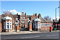
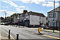
1
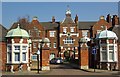
Former Grove Park Hospital
Grove Park Hospital was built to the designs of architect Thomas Dinwiddy as a workhouse for the poor of Greenwich in 1902. It was taken over by the Army in the First World War, and subsequently became a hospital. It is now a housing estate, although some of the hospital buildings have been preserved.
Image: © Jim Osley
Taken: 8 Mar 2011
0.06 miles
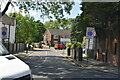
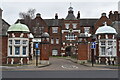
5
Grove Park Hospital / Pennington Way
The splendid buildings at the former Grove Park Hospital which closed in 1994 are now part of a residential estate accessed via Pennington Way through the gate shown here.
Image: © Des Blenkinsopp
Taken: 6 Mar 2020
0.11 miles
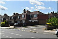
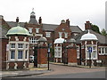
6
Former Grove Park Hospital, now residential
Image: © David Martin
Taken: 15 Feb 2022
0.11 miles
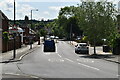
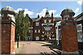
7
The entrance to the Pennington Way estate, SE12
Off Marvels Lane. The buildings have had several uses since they were built in 1902. They were originally a workhouse. At the beginning of WW1 in 1914 the workhouse was requisitioned by the Army Service Corps; its occupants were relocated and the buildings were used as a mobilisation training camp. In 1919 the workhouse was sold to the Metropolitan Asylums Board for use as a hospital for TB patients living in south London. But the buildings remained empty until 1926, when they were adapted as a hospice for TB patients and renamed Grove Park Hospital. By 1945 the Hospital had become a centre for thoracic surgery. It remained a TB and chest hospital until 1977, when it was redesignated as a facility for mentally handicapped patients. The Hospital closed in 1994. For more info, see http://ezitis.myzen.co.uk/grovepark.html.
Image: © Mike Quinn
Taken: 28 Sep 2010
0.11 miles
10
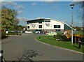
Bannatyne's Health Club, Grove Park SE12
At 35 Marvels Lane. Gym and pool.
Image: © Philip Talmage
Taken: 4 Nov 2005
0.13 miles