IMAGES TAKEN NEAR TO
Sibthorpe Road, LONDON, SE12 9DR
Introduction
This page details the photographs taken nearby to Sibthorpe Road, SE12 9DR by members of the Geograph project.
The Geograph project started in 2005 with the aim of publishing, organising and preserving representative images for every square kilometre of Great Britain, Ireland and the Isle of Man.

There are currently over 7.5m images from over14,400 individuals and you can help contribute to the project by visiting https://www.geograph.org.uk
Image Map
Images are licensed for reuse under creativecommons.org/licenses/by-sa/2.0
Notes
- Clicking on the map will re-center to the selected point.
- The higher the marker number, the further away the image location is from the centre of the postcode.
Image Listing (66 Images Found)
Images are licensed for reuse under creativecommons.org/licenses/by-sa/2.0
Image
Details
Distance
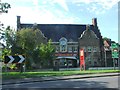
2

The Dutch House, Pub Sign, Eltham
In front of Image beside the A20 Sidcup Road.
Image: © David Anstiss
Taken: 18 Sep 2011
0.03 miles
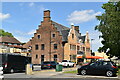
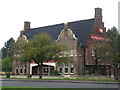
3
The Dutch House public house, London SE12
Image: © Stacey Harris
Taken: 7 Nov 2009
0.03 miles
6
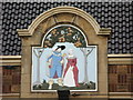
Panel on the Dutch House, Sidcup Road, SE9
See Image
Image: © Mike Quinn
Taken: 23 Sep 2010
0.03 miles
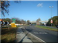
8
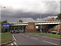
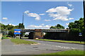
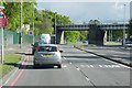
Railway Bridge over the A21 Sidcup Road
The A21 dual carriageway leads from Sidcup towards Eltham.
The bridge carries the railway line between Mottingham and Lee.
Image: © David Anstiss
Taken: 18 Sep 2011
0.05 miles