IMAGES TAKEN NEAR TO
Sibthorpe Road, LONDON, SE12 9DN
Introduction
This page details the photographs taken nearby to Sibthorpe Road, SE12 9DN by members of the Geograph project.
The Geograph project started in 2005 with the aim of publishing, organising and preserving representative images for every square kilometre of Great Britain, Ireland and the Isle of Man.

There are currently over 7.5m images from over14,400 individuals and you can help contribute to the project by visiting https://www.geograph.org.uk
Image Map
Images are licensed for reuse under creativecommons.org/licenses/by-sa/2.0
Notes
- Clicking on the map will re-center to the selected point.
- The higher the marker number, the further away the image location is from the centre of the postcode.
Image Listing (41 Images Found)
Images are licensed for reuse under creativecommons.org/licenses/by-sa/2.0
Image
Details
Distance
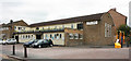
1
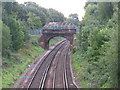
Railway lines east of Westhorne Avenue (A205)
Image: © Mike Quinn
Taken: 23 Sep 2010
0.03 miles
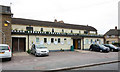
3

St Francis Church, Sibthorpe Road, now Horn Park Community Centre
Chancel end of former church
Image: © John Salmon
Taken: 18 May 2011
0.07 miles
5
St Francis Church, Sibthorpe Road now Horn Park Community Centre
Image: © John Salmon
Taken: 18 May 2011
0.07 miles
6
St Francis Church, Sibthorpe Road, now Horn Park Community Centre
Image: © John Salmon
Taken: 18 May 2011
0.07 miles
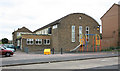
7
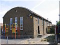
Horn Park Community Centre, Hengist Road
Built 1952 as St Francis church (Anglican), but used as a community centre since around 1981.
Image: © Stephen Craven
Taken: 16 Jul 2005
0.08 miles
8

St Francis Church, Sibthorpe Road, now Horn Park Community Centre
Stained glass window
Image: © John Salmon
Taken: 18 May 2011
0.08 miles
9
St Francis Church, Sibthorpe Road, now Horn Park Community Centre
Image: © John Salmon
Taken: 18 May 2011
0.09 miles
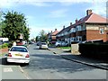
10
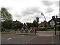
Pelican crossing on Westhorne Avenue
The road is dual-carriageway at this point, with a staggered Pelican crossing.
Image: © Stephen Craven
Taken: 9 Jun 2012
0.09 miles