IMAGES TAKEN NEAR TO
Alwold Crescent, LONDON, SE12 9AG
Introduction
This page details the photographs taken nearby to Alwold Crescent, SE12 9AG by members of the Geograph project.
The Geograph project started in 2005 with the aim of publishing, organising and preserving representative images for every square kilometre of Great Britain, Ireland and the Isle of Man.

There are currently over 7.5m images from over14,400 individuals and you can help contribute to the project by visiting https://www.geograph.org.uk
Image Map
Images are licensed for reuse under creativecommons.org/licenses/by-sa/2.0
Notes
- Clicking on the map will re-center to the selected point.
- The higher the marker number, the further away the image location is from the centre of the postcode.
Image Listing (56 Images Found)
Images are licensed for reuse under creativecommons.org/licenses/by-sa/2.0
Image
Details
Distance
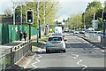
4
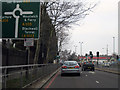
Approaching Clifton's Roundabout
The South Circular Road has just passed from Lewisham into Greenwich Borough.
Image: © Bill Boaden
Taken: 11 Oct 2014
0.07 miles
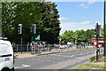
9
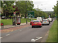
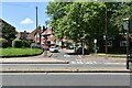
Westhorne Avenue, eastbound
The road - A205 South Circular - is dual-carriageway at this point. The view includes a bus stop and large warning signs for a major road junction ahead (Clifton's Roundabout, junction with the A20).
Image: © Stephen Craven
Taken: 9 Jun 2012
0.10 miles
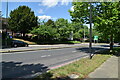
10
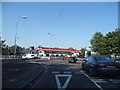
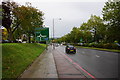
Roundabout on Westhorne Avenue, Eltham
Image: © David Howard
Taken: 18 May 2014
0.10 miles