IMAGES TAKEN NEAR TO
Hedgley Street, LONDON, SE12 8PE
Introduction
This page details the photographs taken nearby to Hedgley Street, SE12 8PE by members of the Geograph project.
The Geograph project started in 2005 with the aim of publishing, organising and preserving representative images for every square kilometre of Great Britain, Ireland and the Isle of Man.

There are currently over 7.5m images from over14,400 individuals and you can help contribute to the project by visiting https://www.geograph.org.uk
Image Map
Images are licensed for reuse under creativecommons.org/licenses/by-sa/2.0
Notes
- Clicking on the map will re-center to the selected point.
- The higher the marker number, the further away the image location is from the centre of the postcode.
Image Listing (179 Images Found)
Images are licensed for reuse under creativecommons.org/licenses/by-sa/2.0
Image
Details
Distance
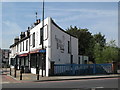
3
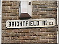
Old sign for Brightfield Road, SE12
The right hand end of this sign can be seen in Image
Image: © Mike Quinn
Taken: 1 Sep 2010
0.06 miles
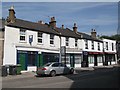
4
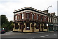
The 'Duke of Edinburgh', Lee High Road
According to publicity outside, this pub specialises in supplying beer from the smaller breweries - presumably microbreweries. It must merit further investigation.
Image: © Dr Neil Clifton
Taken: 15 Sep 2008
0.06 miles
5
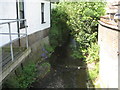
Quaggy River in Lee Green
The Quaggy River is a tributary of the Ravensbourne River and this is the view from Lee Green Bridge. The river has been straightened out by engineers in various places over the course of time but the current trend is to reintroduce the meanders in order to lengthen the watercourse and to reduce its gradient. This is a location where it has been straightened. Old Ordnance Survey maps show it going off to the right here, to somewhere near the present-day junction of Lampmead and Lenham Roads, before turning back left again to its current course. It was straightened here during the late Victorian residential expansion of Lee Green.
Image: © Nigel Cox
Taken: 30 Jun 2013
0.06 miles
7
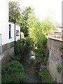
The Quaggy River west of Lee High Road (A20)
Image: © Mike Quinn
Taken: 1 Sep 2010
0.07 miles
8
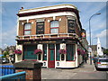
Lee Green: Duke of Edinburgh
This public house appears to have been built as the village of Lee Green expanded outwards in late Victorian times. The Duke of Edinburgh after whom it was named was Prince Alfred, the second son of Queen Victoria, who was given the title in 1866.
Image is visible further along Lee High Road in this view.
Image: © Nigel Cox
Taken: 30 Jun 2013
0.07 miles
9
Lee High Road (A20) / Brightfield Road, SE13
The blue railings mark where the Quaggy River passes under the road - see Image
Image: © Mike Quinn
Taken: 1 Sep 2010
0.08 miles
10
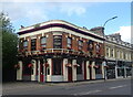
The Duke Of Edinburgh public house
On Lee High Road.
See Image] for sign.
Image: © JThomas
Taken: 24 Jun 2022
0.08 miles