IMAGES TAKEN NEAR TO
Effingham Road, LONDON, SE12 8NZ
Introduction
This page details the photographs taken nearby to Effingham Road, SE12 8NZ by members of the Geograph project.
The Geograph project started in 2005 with the aim of publishing, organising and preserving representative images for every square kilometre of Great Britain, Ireland and the Isle of Man.

There are currently over 7.5m images from over14,400 individuals and you can help contribute to the project by visiting https://www.geograph.org.uk
Image Map
Images are licensed for reuse under creativecommons.org/licenses/by-sa/2.0
Notes
- Clicking on the map will re-center to the selected point.
- The higher the marker number, the further away the image location is from the centre of the postcode.
Image Listing (124 Images Found)
Images are licensed for reuse under creativecommons.org/licenses/by-sa/2.0
Image
Details
Distance
1
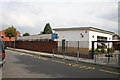
Brindishe Primary School, Wantage Road, Lee
Image: © Dr Neil Clifton
Taken: 15 Sep 2008
0.06 miles
2
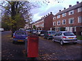
Housing along Burnt Ash Road
Looking towards Lee Green
Image: © David Howard
Taken: 1 Nov 2009
0.11 miles
3
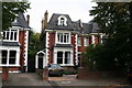
24 Micheldever Road, Lee
Typical of the many fine 4-storey (3 plus basement) houses built in this area just after the start of the 20th century. Only now is it being realised that many houses built since about 1925 were of an inferior standard, with cramped rooms and low ceilings. Like many others of its type, this house is now divided into flats.
Image: © Dr Neil Clifton
Taken: 15 Sep 2008
0.12 miles
4
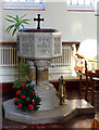
The Good Shepherd, Handen Road, Lee - Font
Image: © John Salmon
Taken: 10 Dec 2005
0.12 miles
5
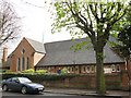
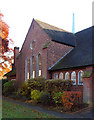
Church of the Good Shepherd, Handen Road, Lee
The original church on the site was consecrated on 12 December 1881 and largely destroyed by firebombs in 1941. It was completely rebuilt in 1957. The old foundations and some portions of the old walls are retained
throughout the building except along the north aisle wall. Further details: http://www.southwark.anglican.org/parishes/144f1
Image: © Stephen Craven
Taken: 14 Apr 2008
0.12 miles
6
Lee Green: the Edmund Halley
A Wetherspoon's pub named after Halley, the famous astronomer with the eponymous comet, who hailed from these parts and is buried in a nearby church.
Image: © Chris Downer
Taken: 14 Sep 2008
0.12 miles
8
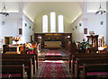
The Good Shepherd, Handen Road, Lee - East end
Image: © John Salmon
Taken: 10 Dec 2005
0.13 miles
9
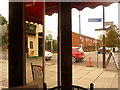
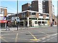
Lee Green: looking out on the world from the Centre Caf
While we await our morning fry-up, we look out onto Burnt Ash Road from the Centre Café, on the corner of the Leegate shopping centre. The corner pillar with its two mirrors produce a confusing sight. The red car is actually being followed by the silver one. The left-hand mirror panel (with the image of the chair-back) is reflecting the view back along the Leegate Centre, with the frontage of Image
Image: © Chris Downer
Taken: 20 Sep 2009
0.13 miles
10
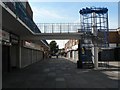
Lee Green: Leegate spiral staircase
The spiral staircase in Image provides access to one of the levels of the car park behind.
Image: © Chris Downer
Taken: 14 Sep 2008
0.13 miles