IMAGES TAKEN NEAR TO
Wantage Road, LONDON, SE12 8NB
Introduction
This page details the photographs taken nearby to Wantage Road, SE12 8NB by members of the Geograph project.
The Geograph project started in 2005 with the aim of publishing, organising and preserving representative images for every square kilometre of Great Britain, Ireland and the Isle of Man.

There are currently over 7.5m images from over14,400 individuals and you can help contribute to the project by visiting https://www.geograph.org.uk
Image Map
Images are licensed for reuse under creativecommons.org/licenses/by-sa/2.0
Notes
- Clicking on the map will re-center to the selected point.
- The higher the marker number, the further away the image location is from the centre of the postcode.
Image Listing (156 Images Found)
Images are licensed for reuse under creativecommons.org/licenses/by-sa/2.0
Image
Details
Distance
1
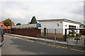
Brindishe Primary School, Wantage Road, Lee
Image: © Dr Neil Clifton
Taken: 15 Sep 2008
0.04 miles
3
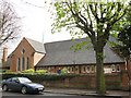
Church of the Good Shepherd, Handen Road, Lee
The original church on the site was consecrated on 12 December 1881 and largely destroyed by firebombs in 1941. It was completely rebuilt in 1957. The old foundations and some portions of the old walls are retained
throughout the building except along the north aisle wall. Further details: http://www.southwark.anglican.org/parishes/144f1
Image: © Stephen Craven
Taken: 14 Apr 2008
0.12 miles
4
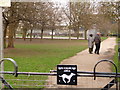
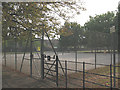
Lee Green: dog exercise area, Manor House Gardens
This narrow stretch of Image, on the south side of the Quaggy River, is set aside for dogs to be off the lead. The couple ahead of us are keeping an eye on their dog, which is out of picture to the right.
The sign in the top-left corner reminds people to clean up after their dog, and that bags for that purpose can be picked up from the park office.
Image: © Chris Downer
Taken: 28 Mar 2010
0.12 miles
5
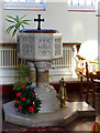
The Good Shepherd, Handen Road, Lee - Font
Image: © John Salmon
Taken: 10 Dec 2005
0.12 miles
8
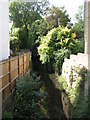
The Quaggy River, Manor House Gardens (5)
Image: © Mike Quinn
Taken: 1 Sep 2010
0.13 miles
10
The Quaggy River west of Brightfield Road, SE12
Image: © Mike Quinn
Taken: 1 Sep 2010
0.13 miles