IMAGES TAKEN NEAR TO
Manor Lane, LONDON, SE12 8LR
Introduction
This page details the photographs taken nearby to Manor Lane, SE12 8LR by members of the Geograph project.
The Geograph project started in 2005 with the aim of publishing, organising and preserving representative images for every square kilometre of Great Britain, Ireland and the Isle of Man.

There are currently over 7.5m images from over14,400 individuals and you can help contribute to the project by visiting https://www.geograph.org.uk
Image Map
Images are licensed for reuse under creativecommons.org/licenses/by-sa/2.0
Notes
- Clicking on the map will re-center to the selected point.
- The higher the marker number, the further away the image location is from the centre of the postcode.
Image Listing (120 Images Found)
Images are licensed for reuse under creativecommons.org/licenses/by-sa/2.0
Image
Details
Distance
1
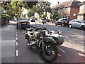
Old Bike, Manor Lane
Painted in wartime green with matching side-car.
Image: © David Anstiss
Taken: 25 Sep 2011
0.02 miles
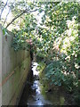
2
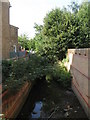
The Quaggy River west of Manor Lane, SE13
Image: © Mike Quinn
Taken: 1 Sep 2010
0.06 miles
3
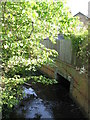
Manor Lane, SE13
The iron railings and brick wall mark where the Quaggy River passes under the road - see Image
Image: © Mike Quinn
Taken: 1 Sep 2010
0.07 miles
4
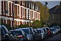
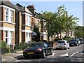
Suburban autumn evening
Last of the sunlight on housefronts in Hereford Gardens.
Image: © David Martin
Taken: 29 Oct 2022
0.07 miles
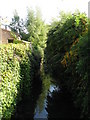
5
The Quaggy River east of Manor Lane, SE13
Image: © Mike Quinn
Taken: 1 Sep 2010
0.07 miles
7
The Quaggy River, Manor House Gardens (2)
Image: © Mike Quinn
Taken: 1 Sep 2010
0.08 miles
8
The Quaggy River north of Manor Park, SE13
Image: © Mike Quinn
Taken: 1 Sep 2010
0.08 miles