IMAGES TAKEN NEAR TO
Courtlands Avenue, LONDON, SE12 8HZ
Introduction
This page details the photographs taken nearby to Courtlands Avenue, SE12 8HZ by members of the Geograph project.
The Geograph project started in 2005 with the aim of publishing, organising and preserving representative images for every square kilometre of Great Britain, Ireland and the Isle of Man.

There are currently over 7.5m images from over14,400 individuals and you can help contribute to the project by visiting https://www.geograph.org.uk
Image Map
Images are licensed for reuse under creativecommons.org/licenses/by-sa/2.0
Notes
- Clicking on the map will re-center to the selected point.
- The higher the marker number, the further away the image location is from the centre of the postcode.
Image Listing (57 Images Found)
Images are licensed for reuse under creativecommons.org/licenses/by-sa/2.0
Image
Details
Distance
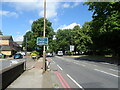
1
Lee: Courtlands Avenue, SE12 (not SE9!)
The road sign incorrectly displays the postcode district SE9 - this is comfortably SE12. This is one of a few offshoots of the main carriageway of Courtlands Avenue, serving even numbers 2 to 90.
Image: © Chris Downer
Taken: 14 Nov 2008
0.01 miles
2
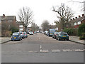
Courtlands Avenue, Lee - looking South
A view from the northern end of the road which is just into the adjacent square.
Image: © Stephen Craven
Taken: 26 Feb 2009
0.06 miles
3
Lee: rear of corrected sign in Horn Park Lane
Looking at the back of this embossed sign, it is clear to see that the original wording was 'SE9' – you can see the bolts either side where the patch has been affixed – see Image
Meanwhile, we look along the main Eltham Road as the 321 bus pulls away from a bus stop.
Image: © Chris Downer
Taken: 15 Nov 2008
0.06 miles
4
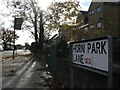
Lee: corrected street sign in Horn Park Lane
The postcode is displayed on a patch that has been bolted onto the sign, over the incorrect version, SE9, which was on the original. See also Image.
Image: © Chris Downer
Taken: 15 Nov 2008
0.07 miles
5
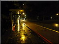
Lee: bus stop on the Eltham Road
A bus stop on the Lewisham-bound side of the A20 Eltham Road. The bus lane operates during peak hours.
Image: © Chris Downer
Taken: 19 Oct 2012
0.08 miles
7
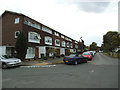
Fairby Road, Lee
Part of an estate built in the 1960s.
Image: © Stephen Craven
Taken: 31 Jul 2014
0.10 miles
9
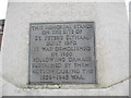
Plaque on St Peter's war memorial, Lee
Image: © Stephen Craven
Taken: 26 Feb 2009
0.12 miles
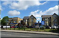
10
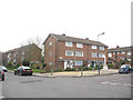
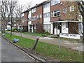
Site of former St Peter's church, Courtlands Avenue, Lee
St Peter's parish church, on the corner of Courtlands Avenue (right) and what is now Lyme Farm Road (foreground), was built in 1871. The church was closed in 1939 due to poor attendance. The building survived World War 2, being used for storage, and was not officially redundant until 1960. The site was sold in 1961 to Wates for housing development for £5000: the extent of the church building is represented by the nearest block in this photo and the one to the left of it.
A new church was built in 1960 on a site on Eltham Road and has itself since been replaced - see Image The war memorial remains and can be seen towards the right of this picture. Image
Image: © Stephen Craven
Taken: 26 Feb 2009
0.12 miles