IMAGES TAKEN NEAR TO
Dorville Road, LONDON, SE12 8ED
Introduction
This page details the photographs taken nearby to Dorville Road, SE12 8ED by members of the Geograph project.
The Geograph project started in 2005 with the aim of publishing, organising and preserving representative images for every square kilometre of Great Britain, Ireland and the Isle of Man.

There are currently over 7.5m images from over14,400 individuals and you can help contribute to the project by visiting https://www.geograph.org.uk
Image Map
Images are licensed for reuse under creativecommons.org/licenses/by-sa/2.0
Notes
- Clicking on the map will re-center to the selected point.
- The higher the marker number, the further away the image location is from the centre of the postcode.
Image Listing (67 Images Found)
Images are licensed for reuse under creativecommons.org/licenses/by-sa/2.0
Image
Details
Distance
1
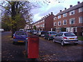
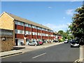
Housing along Burnt Ash Road
Looking towards Lee Green
Image: © David Howard
Taken: 1 Nov 2009
0.05 miles
2
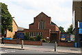
United Reformed Church, Burnt Ash Road, Lee
A modern church built in 1991.
Image: © Dr Neil Clifton
Taken: 15 Sep 2008
0.09 miles
3
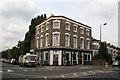
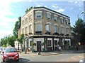
The 'Northbrook', Lee
Large public house at the junction of Southbrook Road with Burnt Ash Road
Image: © Dr Neil Clifton
Taken: 15 Sep 2008
0.12 miles
4
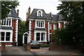
24 Micheldever Road, Lee
Typical of the many fine 4-storey (3 plus basement) houses built in this area just after the start of the 20th century. Only now is it being realised that many houses built since about 1925 were of an inferior standard, with cramped rooms and low ceilings. Like many others of its type, this house is now divided into flats.
Image: © Dr Neil Clifton
Taken: 15 Sep 2008
0.13 miles
7
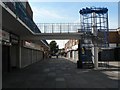
Lee Green: Leegate spiral staircase
The spiral staircase in Image provides access to one of the levels of the car park behind.
Image: © Chris Downer
Taken: 14 Sep 2008
0.17 miles
8
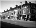
Shopping parade, Burnt Ash Road, Lee SE12
These shops are on the west side of Burnt Ash Road, just north of Lee station, and at the corner of Southbrook Road, which runs down at the extreme right. There are no motor vehicles in view in this 1962 picture.
Image: © Dr Neil Clifton
Taken: 24 Jun 1962
0.17 miles
9
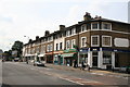
Shops, Burnt Ash Road, Lee
See also Image for a picture of the same location some 46 years earlier.
Image: © Dr Neil Clifton
Taken: 15 Sep 2008
0.17 miles
10
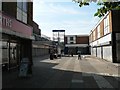
Lee Green: Leegate shopping centre
It is hard to tell whether these are all closed shops, or just do not trade on Sundays. Certainly a quarter of them are without signboards but there is a Woolworth's, an Iceland, a pharmacist, a butcher and a charity shop.
Image: © Chris Downer
Taken: 14 Sep 2008
0.17 miles