IMAGES TAKEN NEAR TO
Cambridge Drive, LONDON, SE12 8AJ
Introduction
This page details the photographs taken nearby to Cambridge Drive, SE12 8AJ by members of the Geograph project.
The Geograph project started in 2005 with the aim of publishing, organising and preserving representative images for every square kilometre of Great Britain, Ireland and the Isle of Man.

There are currently over 7.5m images from over14,400 individuals and you can help contribute to the project by visiting https://www.geograph.org.uk
Image Map
Images are licensed for reuse under creativecommons.org/licenses/by-sa/2.0
Notes
- Clicking on the map will re-center to the selected point.
- The higher the marker number, the further away the image location is from the centre of the postcode.
Image Listing (22 Images Found)
Images are licensed for reuse under creativecommons.org/licenses/by-sa/2.0
Image
Details
Distance
1
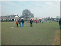
Colfeian Sports Club
Surrounded by residential property in Kidbrooke, picture shows Club house and pavilion overlooking cricket soccer and rugby pitches.
Image: © Dennis Turner
Taken: 5 Feb 2006
0.08 miles
2
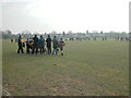
Sunday morning Rugby.
Junior players at Colfeian Sports grounds.
Image: © Dennis Turner
Taken: 5 Feb 2006
0.10 miles
3
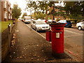
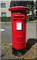
Lee Green: postbox № SE12 16, Cambridge Drive
A fat Victorian postbox by the junction of Eltham Road and Cambridge Drive, along which latter road we are looking. The box is emptied finally at 5:30pm on weekdays and at noon on Saturdays.
Image: © Chris Downer
Taken: 20 Sep 2009
0.13 miles
4
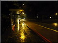
Lee: bus stop on the Eltham Road
A bus stop on the Lewisham-bound side of the A20 Eltham Road. The bus lane operates during peak hours.
Image: © Chris Downer
Taken: 19 Oct 2012
0.15 miles
5
Elizabeth II postbox on Cambridge Drive, Lee
Modern pressed steel box.
Postbox No. SE12 16.
Image: © JThomas
Taken: 24 Jun 2022
0.15 miles
7
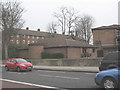
St Peter's church, Eltham Road, Lee
This single-storey community-style Anglican church building is not very noticeable to drivers on the busy A20 (named Eltham Road at this point). It was built in 1983 on the site of a previous church that had suffered from structural problems almost since its construction in 1960. The block of flats behind the church, Raglan Court, was built at the same time. For the site of the original parish church see Image
Image: © Stephen Craven
Taken: 26 Feb 2009
0.16 miles
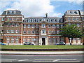
9
Former Ravensbourne Athletic Club Of Ladywell and Lee
Now apartments, this imposing building was apparently built as a residential sports clubhouse https://runner500.wordpress.com/tag/ravens-way/
Image: © David Martin
Taken: 29 Oct 2022
0.16 miles
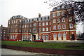
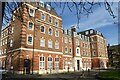
10
Lee Green: Former Ravensbourne Club (1)
This block was built on the north side of Eltham Road as the Ravensbourne Club in 1912 as a residential clubhouse and sports centre for employees of Cook Son & Co (St Pauls) Limited. The four storey block was formed in a “U” shape around a quadrangle at the rear which was originally the swimming pool area. By the mid-2000s the building had deteriorated badly and was in need of either demolition or refurbishment. Because the building was generally structurally sound the latter was the preferred option, and the refurbishment was completed in 2007. This is the front façade. For a view of the rear please see Image
Image: © Nigel Cox
Taken: 30 Jun 2013
0.16 miles