IMAGES TAKEN NEAR TO
Baring Close, Baring Road, LONDON, SE12 0UN
Introduction
This page details the photographs taken nearby to Baring Close, Baring Road, SE12 0UN by members of the Geograph project.
The Geograph project started in 2005 with the aim of publishing, organising and preserving representative images for every square kilometre of Great Britain, Ireland and the Isle of Man.

There are currently over 7.5m images from over14,400 individuals and you can help contribute to the project by visiting https://www.geograph.org.uk
Image Map
Images are licensed for reuse under creativecommons.org/licenses/by-sa/2.0
Notes
- Clicking on the map will re-center to the selected point.
- The higher the marker number, the further away the image location is from the centre of the postcode.
Image Listing (89 Images Found)
Images are licensed for reuse under creativecommons.org/licenses/by-sa/2.0
Image
Details
Distance
3
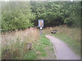
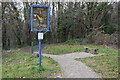
Entrance to Grove Park Nature Reserve
This nature reserve, next to the main railway line between Grove Park and Hither Green, was formerly allotments. It was previously known as Hither Green Nature Reserve. This view is taken from the Capital Ring and Green Chain Walk footpath looking towards the entrance to the reserve.
Image: © Marathon
Taken: 20 Aug 2010
0.06 miles
6
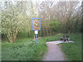
Grove Park Nature Reserve
This nature reserve, next to the main railway line between Grove Park and Hither Green, was formerly allotments. It was previously known as Hither Green Nature Reserve. The main entrance as seen here is reached from the Capital Ring and Green Chain Walk footpath.
Image: © Marathon
Taken: 11 Apr 2011
0.09 miles
8
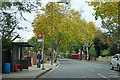
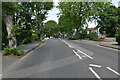
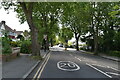
Baring Road, SE12
Baring Road - Coopers Lane bus stop is on the left.
Image: © Robin Webster
Taken: 30 Oct 2011
0.10 miles
9
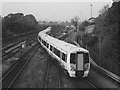
Electrostar leaving Grove Park depot
The 12-coach train snakes its way across the tracks as it leaves the depot on the eastern side of the line, to join the 'up' line towards Charing Cross, from where it will form an evening commuter service.
(The photo, though relatively recent, was scanned in greyscale as a result of light getting into the camera and causing a colour cast on the print that could not easily be removed)
Image: © Stephen Craven
Taken: 5 Nov 2004
0.10 miles
10

Railway sidings and shed, Grove Park
Seen from a long footbridge which carries the Green Chain Walk and the Capital Ring. Bramdean sidings lead to a large carriage servicing shed, 820 feet long with six roads.
Image: © Derek Harper
Taken: 9 May 2013
0.11 miles