IMAGES TAKEN NEAR TO
Burnt Ash Hill, LONDON, SE12 0QF
Introduction
This page details the photographs taken nearby to Burnt Ash Hill, SE12 0QF by members of the Geograph project.
The Geograph project started in 2005 with the aim of publishing, organising and preserving representative images for every square kilometre of Great Britain, Ireland and the Isle of Man.

There are currently over 7.5m images from over14,400 individuals and you can help contribute to the project by visiting https://www.geograph.org.uk
Image Map
Images are licensed for reuse under creativecommons.org/licenses/by-sa/2.0
Notes
- Clicking on the map will re-center to the selected point.
- The higher the marker number, the further away the image location is from the centre of the postcode.
Image Listing (20 Images Found)
Images are licensed for reuse under creativecommons.org/licenses/by-sa/2.0
Image
Details
Distance
1
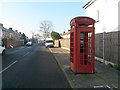
Lee: telephone box in Ashwater Road
The bigger brother of the familiar K6 telephone box, this is a K2 and is relatively rare outside of the more central parts of London. This one is lacking in the glazing department but it does still contain a phone.
Image: © Chris Downer
Taken: 22 Jan 2017
0.04 miles
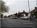
2
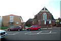
Burnt Ash Methodist church and hall, SE12
In Burnt Ash Hill
Image: © Philip Talmage
Taken: 4 Nov 2005
0.12 miles
3
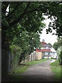
Footpath between Jevington Way and Exford Road, SE12 (2)
This path is not a public right of way - see Image
Image: © Mike Quinn
Taken: 28 Sep 2010
0.15 miles
5
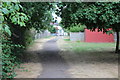
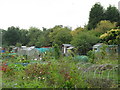
Track to Exford Road from Jevington Way
The path runs past allotments (boundary on left), with a small sycamore tree on the right Image
Image: © M J Roscoe
Taken: 20 Jul 2018
0.17 miles
6
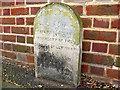
Boundary stone on Winn Road
This rather weathered stone at the junction of Winn Road and Guibal Road marks the boundary between the present boroughs of Greenwich and Lewisham. It is partly illegible; the rest appears to read " .... 20ft ... this point to the boundary of the Borough of Lewisham".
Image: © Stephen Craven
Taken: 16 Apr 2011
0.17 miles
7
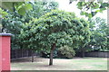
Sycamore opposite Exford Road allotments
Small tree on grass next to permissive path Image
Image: © M J Roscoe
Taken: 20 Jul 2018
0.19 miles
9
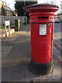
Lee: postbox № SE12 30, Winn Road
This large, Victorian postbox stands at the end of Winn Road, facing Burnt Ash Hill. It has a drop box (see below) attached to its rear, not visible in this picture.
Image: © Chris Downer
Taken: 2 Feb 2015
0.19 miles