IMAGES TAKEN NEAR TO
Baring Road, LONDON, SE12 0PQ
Introduction
This page details the photographs taken nearby to Baring Road, SE12 0PQ by members of the Geograph project.
The Geograph project started in 2005 with the aim of publishing, organising and preserving representative images for every square kilometre of Great Britain, Ireland and the Isle of Man.

There are currently over 7.5m images from over14,400 individuals and you can help contribute to the project by visiting https://www.geograph.org.uk
Image Map
Images are licensed for reuse under creativecommons.org/licenses/by-sa/2.0
Notes
- Clicking on the map will re-center to the selected point.
- The higher the marker number, the further away the image location is from the centre of the postcode.
Image Listing (31 Images Found)
Images are licensed for reuse under creativecommons.org/licenses/by-sa/2.0
Image
Details
Distance
2
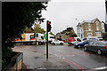
A2212 approaches the South Circular Road
A stranger may be forgiven in thinking he would be joining a reasonably fast flowing ring road designed to avoid most conflicting junction movements via flyovers etc. He would be sadly disillusioned.
Image: © Robin Webster
Taken: 30 Oct 2011
0.05 miles
3
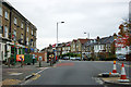
Baring Road, SE12
The A2212. The bus stop is Harland Road (the turning on the right) and is served by route 261 towards Lewisham station.
Image: © Robin Webster
Taken: 30 Oct 2011
0.08 miles
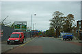
4
Traffic in all directions on Burnt Ash Hill
This is the junction of Burnt Ash Hill with the South Circular Road, viewed in a rain shower.
Image: © Bill Boaden
Taken: 11 Oct 2014
0.08 miles
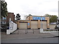
5
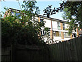
Rear of Kendall House
A block of flats, seen from the adjacent churchyard.
Image: © Stephen Craven
Taken: 10 Sep 2014
0.09 miles
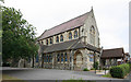
6
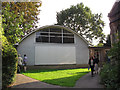
St Mildred's church hall, Lee
The hall is in the grounds of the parish church Image, dates from the 1960s and is due for replacement.
Image: © Stephen Craven
Taken: 10 Sep 2014
0.10 miles
7
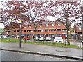
Flats on the Newstead Estate, Burnt Ash Hill
The railings are a recent addition since the flats were refurbished a couple of years ago. Presumably children and dogs were running out into the main road.
Image: © David Howard
Taken: 27 Apr 2014
0.10 miles
8
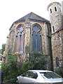
East end of St Mildred's church, Lee
The east end of the church is pentagonal, rather than semi-circular in shape. Polycarbonate sheeting had been put over the windows some years earlier in response to a vandalism problem. See Image for a context photo of the whole building.
Image: © Stephen Craven
Taken: 10 Sep 2014
0.11 miles
9
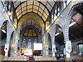
Interior of St Mildred's church, Lee
The inside of the church had been reordered several years ago. See Image for an external photo of the building. The odd colouring is dues to a mixture of strong sunlight and fluorescent artificial lighting - not possible to set a suitable white balance.
Image: © Stephen Craven
Taken: 10 Sep 2014
0.11 miles