IMAGES TAKEN NEAR TO
Kimbolton Close, LONDON, SE12 0JH
Introduction
This page details the photographs taken nearby to Kimbolton Close, SE12 0JH by members of the Geograph project.
The Geograph project started in 2005 with the aim of publishing, organising and preserving representative images for every square kilometre of Great Britain, Ireland and the Isle of Man.

There are currently over 7.5m images from over14,400 individuals and you can help contribute to the project by visiting https://www.geograph.org.uk
Image Map
Images are licensed for reuse under creativecommons.org/licenses/by-sa/2.0
Notes
- Clicking on the map will re-center to the selected point.
- The higher the marker number, the further away the image location is from the centre of the postcode.
Image Listing (71 Images Found)
Images are licensed for reuse under creativecommons.org/licenses/by-sa/2.0
Image
Details
Distance
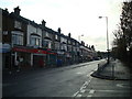
3
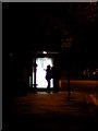
Waiting for the late bus
This woman awaits a bus at 11:30 at night, accompanied by a fellow traveller.
Image: © Chris Downer
Taken: 9 Nov 2007
0.08 miles
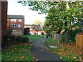
5
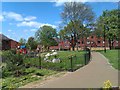
Small park and playground behind Stoneycroft Close
Image: © David Martin
Taken: 10 May 2013
0.09 miles
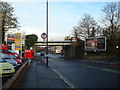
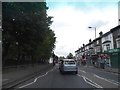
6
Our Lady of Lourdes Catholic Church
On A2212 Burnt Ash Hill.
Image: © David Anstiss
Taken: 27 Nov 2009
0.10 miles
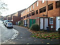
7
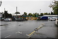
Builders merchant at the end of Dallinger Road
A Travis Perkins site viewed in the rain.
Image: © Bill Boaden
Taken: 11 Oct 2014
0.11 miles