IMAGES TAKEN NEAR TO
Baring Road, LONDON, SE12 0EE
Introduction
This page details the photographs taken nearby to Baring Road, SE12 0EE by members of the Geograph project.
The Geograph project started in 2005 with the aim of publishing, organising and preserving representative images for every square kilometre of Great Britain, Ireland and the Isle of Man.

There are currently over 7.5m images from over14,400 individuals and you can help contribute to the project by visiting https://www.geograph.org.uk
Image Map
Images are licensed for reuse under creativecommons.org/licenses/by-sa/2.0
Notes
- Clicking on the map will re-center to the selected point.
- The higher the marker number, the further away the image location is from the centre of the postcode.
Image Listing (94 Images Found)
Images are licensed for reuse under creativecommons.org/licenses/by-sa/2.0
Image
Details
Distance
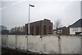
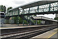
6
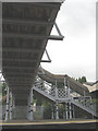
Under the footbridge at Grove Park
This is a view of the underside of the footbridge shown in Image A plaque on one of the stanchions reads "Richards & Son Leicester 1902".
Image: © Stephen Craven
Taken: 26 Aug 2010
0.12 miles
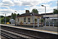
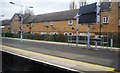
10
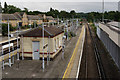
Grove Park Railway Station
Looking towards the south-east, in the direction of Orpington. Out of picture, to the right, platform 1 serves Bromley North.
Image: © Peter Trimming
Taken: 20 Aug 2015
0.12 miles