IMAGES TAKEN NEAR TO
Hotspur Street, LONDON, SE11 6TU
Introduction
This page details the photographs taken nearby to Hotspur Street, SE11 6TU by members of the Geograph project.
The Geograph project started in 2005 with the aim of publishing, organising and preserving representative images for every square kilometre of Great Britain, Ireland and the Isle of Man.

There are currently over 7.5m images from over14,400 individuals and you can help contribute to the project by visiting https://www.geograph.org.uk
Image Map
Images are licensed for reuse under creativecommons.org/licenses/by-sa/2.0
Notes
- Clicking on the map will re-center to the selected point.
- The higher the marker number, the further away the image location is from the centre of the postcode.
Image Listing (124 Images Found)
Images are licensed for reuse under creativecommons.org/licenses/by-sa/2.0
Image
Details
Distance
1
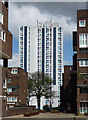
Ethelred Estate, Lollard Street (1)
Built 1969-72. The tower is Elkington Point, one of three which have recently been re-clad.
Image: © Stephen Richards
Taken: 15 Apr 2012
0.03 miles
2
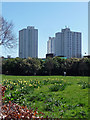
Ethelred Estate, Lollard Street (2)
Built 1969-72. The towers, Elkington Point, Ward Point and Brittany Point, have recently been re-clad.
The green space is off Fitzalan Street.
Image: © Stephen Richards
Taken: 20 Apr 2013
0.03 miles
3
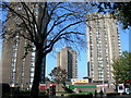
Ethelred Estate, Kennington (1)
Photo taken from Kennington Road.
Image: © Danny P Robinson
Taken: 5 Oct 2007
0.04 miles
4
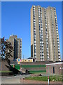
Ethelred Estate, Kennington (2)
The concrete sections used to build the tower blocks can clearly be seen in this picture.
Image: © Danny P Robinson
Taken: 5 Oct 2007
0.04 miles
5
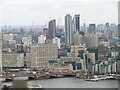
London - Kennington Skyline
View from the Lift 109 elevator atop the north-western chimney of Battersea Power Station. From 109 metres above this gives panoramic views over London, including east to Vauxhall Cross and the high rise apartment blocks of inner city Kennington.
Image: © Colin Smith
Taken: 25 Mar 2024
0.06 miles
6
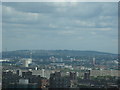
View of southeast London and Kent from Altitude 360
Taken whilst attending a London Photo Walk, this is a view of southeast London and Kent taken from the viewing gallery of Altitude 360 on the top floor of the Millbank Tower looking northeast. I'm pretty sure that the chimney that can just be seen on the horizon at the extreme left of the image is the one belonging to Littlebrook Power Station in Dartford, featured in Image
Image: © Robert Lamb
Taken: 29 Aug 2010
0.06 miles
7
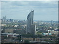
View of the Strata Tower in Elephant & Castle from Altitude 360
Taken whilst attending a London Photo Walk, this is a view of the Strata Tower in Elephant & Castle, taken from the viewing gallery of Altitude 360 on the top floor of the Millbank Tower looking roughly east/southeast.
Image: © Robert Lamb
Taken: 29 Aug 2010
0.08 miles
8
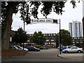
Ethelred TMO
One entrance to the Ethelred Estate, on Black Prince Road. The acronym puzzled me; research shows that TMO stands for Tenant Management Organisation, a form of housing co-operative.
Image: © Stephen Craven
Taken: 17 Aug 2013
0.08 miles
9
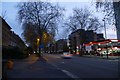
Texaco, Kennington Road
Looking along Kennington Road towards a Texaco fuel station in the dusk.
Image: © DS Pugh
Taken: 11 Dec 2015
0.09 miles
10
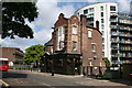
Lambeth: The 'Black Prince', Black Prince Road
Perhaps in view of its name, one can excuse the black colour in which this pub. is painted. But it would greatly benefit from some cream relief around the windows. But that, of course, would need cleaning...
Image: © Dr Neil Clifton
Taken: 23 Jun 2012
0.09 miles