IMAGES TAKEN NEAR TO
Hotspur Street, LONDON, SE11 6TR
Introduction
This page details the photographs taken nearby to Hotspur Street, SE11 6TR by members of the Geograph project.
The Geograph project started in 2005 with the aim of publishing, organising and preserving representative images for every square kilometre of Great Britain, Ireland and the Isle of Man.

There are currently over 7.5m images from over14,400 individuals and you can help contribute to the project by visiting https://www.geograph.org.uk
Image Map
Images are licensed for reuse under creativecommons.org/licenses/by-sa/2.0
Notes
- Clicking on the map will re-center to the selected point.
- The higher the marker number, the further away the image location is from the centre of the postcode.
Image Listing (134 Images Found)
Images are licensed for reuse under creativecommons.org/licenses/by-sa/2.0
Image
Details
Distance
1
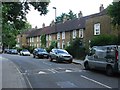
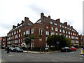
Ethelred Estate, Kennington (1)
Photo taken from Kennington Road.
Image: © Danny P Robinson
Taken: 5 Oct 2007
0.03 miles
2
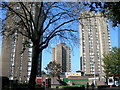
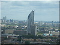
View of southeast London and Kent from Altitude 360
Taken whilst attending a London Photo Walk, this is a view of southeast London and Kent taken from the viewing gallery of Altitude 360 on the top floor of the Millbank Tower looking northeast. I'm pretty sure that the chimney that can just be seen on the horizon at the extreme left of the image is the one belonging to Littlebrook Power Station in Dartford, featured in Image
Image: © Robert Lamb
Taken: 29 Aug 2010
0.04 miles
3
Ethelred TMO
One entrance to the Ethelred Estate, on Black Prince Road. The acronym puzzled me; research shows that TMO stands for Tenant Management Organisation, a form of housing co-operative.
Image: © Stephen Craven
Taken: 17 Aug 2013
0.05 miles
4
Newquay House
This building on Newburn Street presumably takes its name from Newquay in Cornwall, since it is part of the Duchy of Cornwall estate. Listed grade 2 (list entry number 1065012).
Image: © Stephen Craven
Taken: 17 Aug 2013
0.05 miles
5
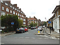
Newburn Street
Looking from the Black Prince Road end, the street is one-way with a segregated contraflow cycle lane.
Image: © Stephen Craven
Taken: 17 Aug 2013
0.05 miles
6
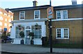
Old shop on Black Prince Road, Lambeth
The building was built for the Duchy of Cornwall in 1914
Image: © David Howard
Taken: 27 Mar 2022
0.05 miles
7
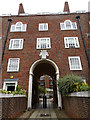
Newquay House, entrance
The Prince of Wales’s feathers appear over the entrance, because it is part of the Duchy of Cornwall estate. For context, see Image
Image: © Stephen Craven
Taken: 17 Aug 2013
0.06 miles
8
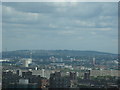
View of the Strata Tower in Elephant & Castle from Altitude 360
Taken whilst attending a London Photo Walk, this is a view of the Strata Tower in Elephant & Castle, taken from the viewing gallery of Altitude 360 on the top floor of the Millbank Tower looking roughly east/southeast.
Image: © Robert Lamb
Taken: 29 Aug 2010
0.06 miles
9
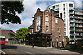
Lambeth: The 'Black Prince', Black Prince Road
Perhaps in view of its name, one can excuse the black colour in which this pub. is painted. But it would greatly benefit from some cream relief around the windows. But that, of course, would need cleaning...
Image: © Dr Neil Clifton
Taken: 23 Jun 2012
0.06 miles