IMAGES TAKEN NEAR TO
Lollard Street, LONDON, SE11 6PX
Introduction
This page details the photographs taken nearby to Lollard Street, SE11 6PX by members of the Geograph project.
The Geograph project started in 2005 with the aim of publishing, organising and preserving representative images for every square kilometre of Great Britain, Ireland and the Isle of Man.

There are currently over 7.5m images from over14,400 individuals and you can help contribute to the project by visiting https://www.geograph.org.uk
Image Map
Images are licensed for reuse under creativecommons.org/licenses/by-sa/2.0
Notes
- Clicking on the map will re-center to the selected point.
- The higher the marker number, the further away the image location is from the centre of the postcode.
Image Listing (216 Images Found)
Images are licensed for reuse under creativecommons.org/licenses/by-sa/2.0
Image
Details
Distance
1
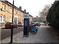
Barclays Bike Station, Lollard Street
Docking station on Lombard Street near a former school.
Image: © David Anstiss
Taken: 20 Nov 2011
0.01 miles
2
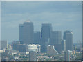
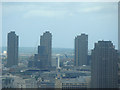
View of Canary Wharf from Altitude 360
Taken whilst attending a London Photo Walk, this is a view of Canary Wharf taken from the viewing gallery of Altitude 360 on the top floor of the Millbank Tower looking east.
Image: © Robert Lamb
Taken: 29 Aug 2010
0.02 miles
3
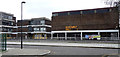
Former Lilian Baylis School, Lollard Street
Designed by The Architects' Co-Partnership for the London County Council in 1962-64. Quite a bold building of dark-brown brick with the hall supported on thin, white piers. Its future is uncertain. The school moved out in 2005 and it is currently used as a community centre, but is on English Heritage's Heritage at Risk Register. Grade II listed.
Image: © Stephen Richards
Taken: 6 Mar 2011
0.03 miles
4
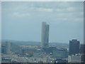
Unknown building from Altitude 360
Taken whilst attending a London Photo Walk, this is a view of an unknown building (if anybody can name it, I'll be very grateful), looking northeast.
Image: © Robert Lamb
Taken: 29 Aug 2010
0.04 miles
5
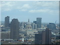
View of St Paul's Cathedral from Altitude 360
Taken whilst attending a London Photo Walk, this is a view of St Paul's Cathedral taken from the viewing gallery of Altitude 360 on the top floor of the Millbank Tower looking east.
Image: © Robert Lamb
Taken: 29 Aug 2010
0.04 miles
6
Doorstep Green
Lambeth Walk - Doorstep Green.
Image: © Alan Hughes
Taken: 28 Oct 2016
0.06 miles
7

Houses in Old Paradise Street, Lambeth
Picture is taken from Lambeth Walk
Image: © PAUL FARMER
Taken: 23 Apr 2011
0.07 miles
8
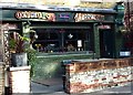
The Royal Oak
Oxymoron at the Royal Oak, Lambeth.
Image: © Alan Hughes
Taken: 28 Oct 2016
0.08 miles
9
View of the Barbican Towers from Altitude 360
Taken whilst attending a London Photo Walk, this is a view of the Barbican Towers taken from the viewing gallery of Altitude 360 on the top floor of the Millbank Tower looking northeast.
Image: © Robert Lamb
Taken: 29 Aug 2010
0.09 miles
10
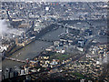
Westminster from the air
Archbishop's Park and St Thomas Hospital can be seen on the south bank of the Thames, with the Palace of Westminster, London Eye and Waterloo railway station also prominent. The Thames bridges are (left to right) Lambeth, Westminster, Hungerford with Golden Jubilee bridges and Waterloo Bridge.
Image: © Thomas Nugent
Taken: 28 Feb 2019
0.09 miles