IMAGES TAKEN NEAR TO
Newport Street, LONDON, SE11 6AQ
Introduction
This page details the photographs taken nearby to Newport Street, SE11 6AQ by members of the Geograph project.
The Geograph project started in 2005 with the aim of publishing, organising and preserving representative images for every square kilometre of Great Britain, Ireland and the Isle of Man.

There are currently over 7.5m images from over14,400 individuals and you can help contribute to the project by visiting https://www.geograph.org.uk
Image Map
Images are licensed for reuse under creativecommons.org/licenses/by-sa/2.0
Notes
- Clicking on the map will re-center to the selected point.
- The higher the marker number, the further away the image location is from the centre of the postcode.
Image Listing (534 Images Found)
Images are licensed for reuse under creativecommons.org/licenses/by-sa/2.0
Image
Details
Distance
1
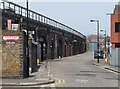
Newport Street
Railway arches under the line between Vauxhall and Waterloo.
The church spire in the distance is that of Christ Church at the junction of Kennington Road and Westminster Bridge Road (Image]).
Image: © Stephen Richards
Taken: Unknown
0.01 miles
3
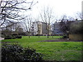
Lambeth High Street Recreation Ground
Taken from Lambeth High Street the recreation ground occupies a site used from 1703-1853 as a burial ground
Image: © PAUL FARMER
Taken: 28 Feb 2009
0.05 miles
4
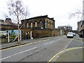
Former Lambeth Ragged School, Newport Street
Built in 1851 by Henry Benjamin Hanbury Beaufoy as a memorial to his wife at a cost of £10,000, and now used as an art gallery.
At the school's opening, Lord Ashley declared that, "There was no reason whatever why Lambeth should not rescue itself from the present disgraceful opprobrium which attached to it.". Some things never change.
Ragged schools were free schools for poor vagrant children. They were founded by Lord Shaftesbury in 1844, and by the time of the 1870 Education Act there were 350 which were gradually absorbed into the Board School system.
Information from the Vauxhall Society.
On the left a train makes its way from Waterloo towards Vauxhall.
Image: © Stephen Richards
Taken: Unknown
0.05 miles
5
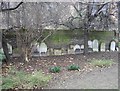
Grave Stones
Lambeth High Street Recreation Ground, these stones were moved to the edge of the park when it was reopened as a public garden in 1884.
Image: © PAUL FARMER
Taken: 28 Feb 2009
0.05 miles
6
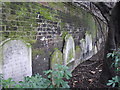
Grave Stones
Lambeth High Street Recreation Ground, these stones were moved to the edge of the park when it was reopened as a public garden in 1884. The graveyard ceased being used in 1853-the stone to the left is dated 1850.
Image: © PAUL FARMER
Taken: 28 Feb 2009
0.06 miles
7
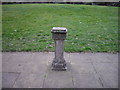
Stone Column
Originally probably held a sundial in Lambeth High Street Recreation Ground
Image: © PAUL FARMER
Taken: 28 Feb 2009
0.06 miles
9
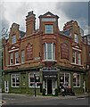
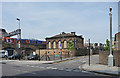
Vauxhall : former Queen's Head public house
"The Queen's Head public house, 71 Black Prince Road, Lambeth (previously No.48 Broad Street). The pub existed pre-1780 and was rebuilt in 1890. Initially a Free House, it was owned by Messrs Barclay Perkins and later Courage. Charlie Chaplin's uncle was the licensee in 1900. It has since closed and in 2011 became a cafe." - https://boroughphotos.org/lambeth/queens-head-vauxhall-walk-lambeth/
Image: © Jim Osley
Taken: 31 Aug 2023
0.07 miles
