IMAGES TAKEN NEAR TO
Kennington Oval, LONDON, SE11 5SL
Introduction
This page details the photographs taken nearby to Kennington Oval, SE11 5SL by members of the Geograph project.
The Geograph project started in 2005 with the aim of publishing, organising and preserving representative images for every square kilometre of Great Britain, Ireland and the Isle of Man.

There are currently over 7.5m images from over14,400 individuals and you can help contribute to the project by visiting https://www.geograph.org.uk
Image Map
Images are licensed for reuse under creativecommons.org/licenses/by-sa/2.0
Notes
- Clicking on the map will re-center to the selected point.
- The higher the marker number, the further away the image location is from the centre of the postcode.
Image Listing (303 Images Found)
Images are licensed for reuse under creativecommons.org/licenses/by-sa/2.0
Image
Details
Distance
1
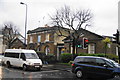
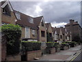
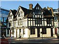
St Mark's School
Housed in an old school building dating from 1824, which still shows the separate wings for boys and girls. Both wings are of equal size and appearance.
Image: © Bill Boaden
Taken: 31 Jan 2014
0.01 miles
2
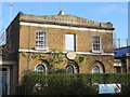
St Marks CE School
The 1820s saw the foundation of two schools at the Oval, Kennington. After raising the necessary voluntary subscriptions, the boys' school opened at the end of 1824 and the girls' school in the spring of 1825. The name proposed for the schools was the Kennington and South Lambeth National School, but they were soon referred to as the National Schools or District Schools, even the Oval Schools. In reflection of the close links with St Mark's Church, the name was later changed to St Mark Kennington Schools. The school is now known as St Mark's CE Primary School.http://discovery.nationalarchives.gov.uk/details/rd/125dcaa7-2aff-4f20-84db-749d75b8bd92
Image: © Richard Rogerson
Taken: 22 Nov 2015
0.01 miles
3
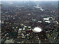
The Oval cricket ground from the air
As seen from a flight from Glasgow approaching London City Airport.
Image: © Thomas Nugent
Taken: 6 Feb 2012
0.02 miles
4
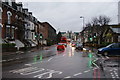
Harleyford Road on a wet day
Looking west from the Kia Oval.
Image: © Bill Boaden
Taken: 31 Jan 2014
0.03 miles
5
Detail of 55 Harleyford Road
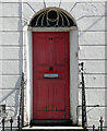
One of the doorcases in this group Image Fluted quarter-columns and teardrop fanlight.
Image: © Stephen Richards
Taken: 21 Apr 2013
0.03 miles
6
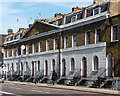
43-55 Harleyford Road
A satisfying early C19th composition, symmetrical about a broad pediment and tied together by a broad platband. Sample doorcase: Image Grade II listed.
Image: © Stephen Richards
Taken: 21 Apr 2013
0.03 miles
8
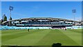
Kia Oval - JM Finn stand
The four-tier grandstand at the Vauxhall end of the ground was completed in May 2005, replacing the old Surridge, Fender, Jardine, and Peter May north stands. It increased the ground capacity to around 23,000.
From completion until 2020 it was known as the OCS stand, as it was sponsored by Outsourced Client Solutions International Facilities Management Services. After a brief period as the 1845 stand, another sponsorhip deal in 2001 saw it renamed the JM Finn stand.
https://www.jmfinn.com/our-thinking/jm-finn-stand-kia-oval
Image: © Mark Percy
Taken: 7 Aug 2022
0.05 miles
10
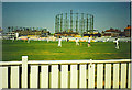
Kennington Oval and Gas Holder
Surrey Schools 6-a-Side Finals in progress with landmark 'gasometer' overlooking the ground.
Image: © Colin Smith
Taken: 20 Jul 1996
0.06 miles