IMAGES TAKEN NEAR TO
Tyers Street, LONDON, SE11 5NR
Introduction
This page details the photographs taken nearby to Tyers Street, SE11 5NR by members of the Geograph project.
The Geograph project started in 2005 with the aim of publishing, organising and preserving representative images for every square kilometre of Great Britain, Ireland and the Isle of Man.

There are currently over 7.5m images from over14,400 individuals and you can help contribute to the project by visiting https://www.geograph.org.uk
Image Map
Images are licensed for reuse under creativecommons.org/licenses/by-sa/2.0
Notes
- Clicking on the map will re-center to the selected point.
- The higher the marker number, the further away the image location is from the centre of the postcode.
Image Listing (328 Images Found)
Images are licensed for reuse under creativecommons.org/licenses/by-sa/2.0
Image
Details
Distance
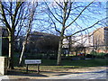
1
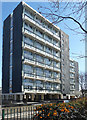
Coverley Point, Vauxhall Walk
Part of the Vauxhall Gardens Estate, begun in the 1950s. Coverley and the tower beyond, Haymans Point, date from c1966, and the duplex arrangement (and pilotis) may hint at a Corbusian influence.
Image: © Stephen Richards
Taken: 20 Apr 2013
0.00 miles
2
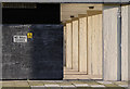
No Ball Games
This sign, here seen on Coverley Point beside Vauxhall Walk, is to be found on housing estates all over London. And we wonder why our children complain they 'have nothing to do'!
The bright afternoon sunshine highlights the wood graining effect on the concrete pillars of this Lambeth tower block.
Image: © Martin Addison
Taken: 2 Dec 2011
0.01 miles
5
Pedlars Park Vauxhall Walk Lambeth
Salamanca Street runs through the park
Image: © PAUL FARMER
Taken: 7 Mar 2010
0.04 miles
6
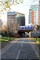
Salamanca Street
Seen from Vauxhall Walk. The bridge carries the South Western railway line from Waterloo to Clapham Junction. The building just to the left of centre is The Park Hotel.
Image: © Martin Addison
Taken: 2 Dec 2011
0.05 miles
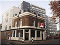
7
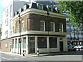
Lambeth: The 'Queen's Head', Black Prince Road
Whether this is still a pub., or merely a cafe bistro, is uncertain. In the background, the bridge carries the ex-LSWR main line to Waterloo.
Image: © Dr Neil Clifton
Taken: 23 Jun 2012
0.06 miles
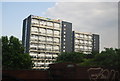
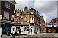
8
Former retail premises on Jonathan Street
On the junction of Jonathan Street and Tyers Street.
In the background are blocks of housing, Vauxhall Gardens Estate.
Image: © David Anstiss
Taken: 20 Nov 2011
0.06 miles
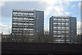
10
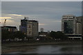
View of towerblocks near Vauxhall from Lambeth Bridge
Looking south-southeast.
Image: © Robert Lamb
Taken: 9 Aug 2014
0.06 miles