IMAGES TAKEN NEAR TO
Vauxhall Street, LONDON, SE11 5LD
Introduction
This page details the photographs taken nearby to Vauxhall Street, SE11 5LD by members of the Geograph project.
The Geograph project started in 2005 with the aim of publishing, organising and preserving representative images for every square kilometre of Great Britain, Ireland and the Isle of Man.

There are currently over 7.5m images from over14,400 individuals and you can help contribute to the project by visiting https://www.geograph.org.uk
Image Map
Images are licensed for reuse under creativecommons.org/licenses/by-sa/2.0
Notes
- Clicking on the map will re-center to the selected point.
- The higher the marker number, the further away the image location is from the centre of the postcode.
Image Listing (289 Images Found)
Images are licensed for reuse under creativecommons.org/licenses/by-sa/2.0
Image
Details
Distance
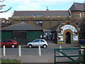
1
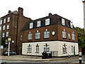
The Rising Sun
This building on the corner of Dolland Street and Vauxhall Street still had a pub sign outside but did not look like a functioning pub.
Image: © Stephen Craven
Taken: 17 Aug 2013
0.05 miles
2
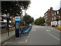
Vauxhall Street docking station
A hire bike docking station off Kennington Lane.
Image: © Stephen Craven
Taken: 17 Aug 2013
0.05 miles
3
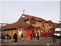
The Apostolic Church, All Nations Centre, Lambeth
Religious building on the junction of St Oswald's Street (on the left) and Tyers Terrace (on the right).
See http://www.apostolic-anc.org/ for more details.
Image: © David Anstiss
Taken: 20 Nov 2011
0.05 miles
4
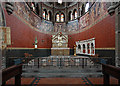
St Peter, Kennington Lane, Vauxhall, London SE11
Image: © John Salmon
Taken: 8 May 2010
0.07 miles
5
Vauxhall City Farm
Vauxhall City Farm was transformed from derelict land in 1977 by volunteers into a working farm. http://www.vauxhallcityfarm.info/
Image: © Oxyman
Taken: 18 Oct 2008
0.07 miles
6
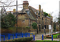
Former St Peter's School, Lambeth
Grade II* listed building in St Oswald's Place, Vauxhall. Built 1860-1861 to the designs of architect John Loughborough Pearson. Later additions, fully described at this https://historicengland.org.uk/listing/the-list/list-entry/1064944 . Converted into residential accommodation.
Image: © Jim Osley
Taken: 10 Jan 2014
0.07 miles
7
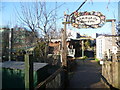
Entrance to the community garden at Vauxhall City Farm
Vauxhall City Farm has been in existence since 1977 and its compact site holds a wide variety of animals including sheep, cows, goats, alpacas and pigs. More detail about this delightful resource, including more about its history, can be found at http://www.vauxhallcityfarm.org/ This view looks towards the community garden at the north end of the farm.
Image: © Marathon
Taken: 1 Feb 2012
0.08 miles
8
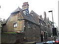
Former St Peter's School, Lambeth
Former school now converted into a terrace of houses on St Oswald's Place.
The building is Grade II listed.
See http://www.britishlistedbuildings.co.uk/en-204620-former-st-peter-s-school-38-lambeth for more details about the building.
Image: © David Anstiss
Taken: 20 Nov 2011
0.08 miles
9
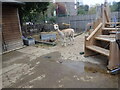
An alpaca at Vauxhall City Farm
Vauxhall City Farm has been in existence since 1977 and its compact site holds a wide variety of animals including sheep, ducks, turkeys, chickens, rabbits goats, alpacas and pigs. It also has a cafe.
More detail about this delightful resource, including more about its history, can be found at http://www.vauxhallcityfarm.org/
Image: © Marathon
Taken: 19 Oct 2021
0.08 miles
10
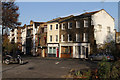
Tyers Street
A small shops and houses terrace seen from Spring Gardens. The shops in these premises have long since been converted into living accommodation as the small local shop gave way to the economic pressures of the supermarkets. The street is named after the Tyers family who opened Spring Gardens, then also known as Vauxhall Pleasure Gardens, in 1661. A full history of the gardens can be found at http://www.vauxhallandkennington.org.uk/sgdetail.shtml .
Image: © Martin Addison
Taken: 2 Dec 2011
0.08 miles