IMAGES TAKEN NEAR TO
Kennington Oval, LONDON, SE11 5BU
Introduction
This page details the photographs taken nearby to Kennington Oval, SE11 5BU by members of the Geograph project.
The Geograph project started in 2005 with the aim of publishing, organising and preserving representative images for every square kilometre of Great Britain, Ireland and the Isle of Man.

There are currently over 7.5m images from over14,400 individuals and you can help contribute to the project by visiting https://www.geograph.org.uk
Image Map
Images are licensed for reuse under creativecommons.org/licenses/by-sa/2.0
Notes
- Clicking on the map will re-center to the selected point.
- The higher the marker number, the further away the image location is from the centre of the postcode.
Image Listing (272 Images Found)
Images are licensed for reuse under creativecommons.org/licenses/by-sa/2.0
Image
Details
Distance
1
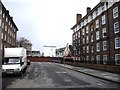
Social Housing in Clayton Street
Looking toward The Brit Oval
Image: © PAUL FARMER
Taken: 22 Nov 2009
0.02 miles
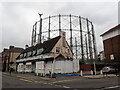
2
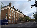
Read House, Clayton Street
This adjoins Image (left); the gasometer can be seen. Clayton Street connects the Oval to Kennington Road at the far end.
Image: © Derek Harper
Taken: 17 Oct 2011
0.02 miles
3
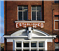
Incised plaque, Montford Place
This incised plaque is above the entrance to the Beefeater Gin distillery, in which a visitor centre has been created. Read more at this http://www.chivasbrothers.com/newsroom/news-area/news-detail.aspx?newsId=14533.
Image: © Jim Osley
Taken: 10 Jan 2014
0.03 miles
4
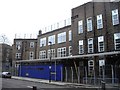
Henry Fawcett Primary School Clayton Street entrance
Image: © PAUL FARMER
Taken: 22 Nov 2009
0.04 miles
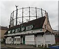
5
The Cricketers, Kennington Oval
A closer view of the closed pub shown in Image, with the gasometer behind.
Image: © Derek Harper
Taken: 17 Oct 2011
0.04 miles
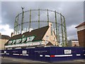
6
The derelict Cricketers pub
The Cricketers pub next to Kennington Oval has been closed and derelict since 2002. In March 2019, planning permission was granted for demolition and construction of a new residential development with a replacement ground floor public house. Behind are the famous Grade II gasholders, familiar from test matches at the Oval. The shape of the Oval Cricket Ground was determined by the pre-existing street pattern – not the other way around.
Image: © Marathon
Taken: 19 Oct 2021
0.04 miles
7
The derelict Cricketers pub
The Cricketers pub next to Kennington Oval has been closed and derelict since 2002. In March 2019, planning permission was granted for demolition and construction of a new residential development with a replacement ground floor public house. Behind are the famous Grade II gasholders, familiar from test matches at the Oval. The shape of the Oval Cricket Ground was determined by the pre-existing street pattern – not the other way around.
Image: © Marathon
Taken: 19 Oct 2021
0.04 miles
8

The Cricketers Public House, Kennington Oval
Now closed and has been so since at least June 2007 when this photo was taken: http://www.flickr.com/photos/captainzep/811395717/#/
Image: © PAUL FARMER
Taken: 23 Jan 2011
0.04 miles
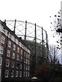
10
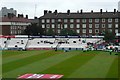
The Oval cricket ground
The ground is surrounded by housing blocks built by the old Greater London Council. Where the stands are low enough, they still provide a good view into the ground, and therefore presumably sell for a lot of money. The windows are usually packed with extra spectators, except today when rain has stopped play.
Image: © Graham Horn
Taken: 9 Aug 2008
0.05 miles