IMAGES TAKEN NEAR TO
Kennington Park Road, LONDON, SE11 4JE
Introduction
This page details the photographs taken nearby to Kennington Park Road, SE11 4JE by members of the Geograph project.
The Geograph project started in 2005 with the aim of publishing, organising and preserving representative images for every square kilometre of Great Britain, Ireland and the Isle of Man.

There are currently over 7.5m images from over14,400 individuals and you can help contribute to the project by visiting https://www.geograph.org.uk
Image Map (Loading...)


Getting Data...Please wait
Leaflet Map data © OpenStreetMap
Images are licensed for reuse under creativecommons.org/licenses/by-sa/2.0
Notes
- Clicking on the map will re-center to the selected point.
- The higher the marker number, the further away the image location is from the centre of the postcode.
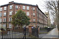
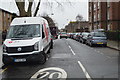
Image Listing (171 Images Found)
Images are licensed for reuse under creativecommons.org/licenses/by-sa/2.0
Image
Details
Distance
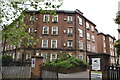
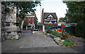
3
Guinness Trust dwellings, Kennington
Built in the 1920s to designs by architect Charles Joseph.
Image: © Jim Osley
Taken: 31 Jan 2018
0.03 miles
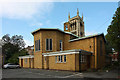
5
St Mary, Kennington Park Road, Newington, London SE11
Image: © John Salmon
Taken: 16 Oct 2010
0.05 miles
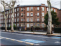
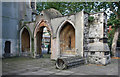
9
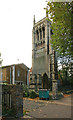
St Mary, Kennington Park Road, Newington
Tower of lost church.
Image: © John Salmon
Taken: 16 Oct 2010
0.05 miles
10
St Mary, Kennington Park Road, Newington, London SE11
Image: © John Salmon
Taken: 16 Oct 2010
0.05 miles