IMAGES TAKEN NEAR TO
Ravensdon Street, LONDON, SE11 4AR
Introduction
This page details the photographs taken nearby to Ravensdon Street, SE11 4AR by members of the Geograph project.
The Geograph project started in 2005 with the aim of publishing, organising and preserving representative images for every square kilometre of Great Britain, Ireland and the Isle of Man.

There are currently over 7.5m images from over14,400 individuals and you can help contribute to the project by visiting https://www.geograph.org.uk
Image Map
Images are licensed for reuse under creativecommons.org/licenses/by-sa/2.0
Notes
- Clicking on the map will re-center to the selected point.
- The higher the marker number, the further away the image location is from the centre of the postcode.
Image Listing (215 Images Found)
Images are licensed for reuse under creativecommons.org/licenses/by-sa/2.0
Image
Details
Distance
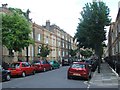
3
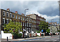
1-20 Cleaver Square
The late C18th/early C19th south side of a long thin rectangle. Two-bay houses in three storeys plus basements. Grade II listed.
Image: © Stephen Richards
Taken: 20 Apr 2013
0.05 miles
4
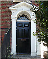
Detail of 152 Kennington Park Road
Open pedimented doorcase with a radial fanlight.
Wider view of terrace: Image
Image: © Stephen Richards
Taken: 20 Apr 2013
0.07 miles
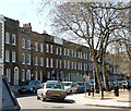
5
136-162 Kennington Park Road
A good long Georgian terrace, each house of three bays, and three storeys plus basement except the central three houses which have an extra storey. Pevsner dates it to c1775. Grade II listed.
Image: © Stephen Richards
Taken: 21 Apr 2012
0.07 miles
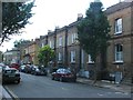
6
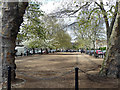
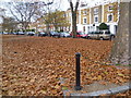
Cleaver Square
Laid out from 1789, when it was known as Prince's Square, apparently the first square south of the Thames.
A pleasant enclave sandwiched between Kennington Road and Kennington Park Road.
Boules was being played at the far end.
Image: © Stephen Richards
Taken: 15 Apr 2012
0.07 miles
7
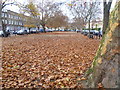
Cleaver Square, Kennington
Formerly known as Prince's Square, Cleaver Square is a favourite with MPs as it is close to the Houses of Parliament. Its terraces dates from 1789 to the mid 19th century. It was built on land belonging to Mary Cleaver who died in 1797 and her daughter Mary Ann Cleaver who surrendered it in 1815.
Image: © Marathon
Taken: 23 Nov 2011
0.07 miles
9
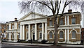
Former town hall, Kennington Road
"Clumsy but quite imposing classical front", was Pevsner's verdict and who am I to disagree? Built 1853 by Willshire & Parris. The front is divided by giant pilasters, and the "imposing-ness" is conveyed by means of a giant Tuscan portico. Grade II listed.
It was used as a town hall until 1908, after which it was used by the Church of England as offices, later privately bought and currently occupied by the Countryside Alliance.
Image: © Stephen Richards
Taken: 12 Mar 2011
0.07 miles
10
Cleaver Square, Kennington
Formerly known as Prince's Square, Cleaver Square is a favourite with MPs as it is close to the Houses of Parliament. Its terraces dates from 1789 to the mid 19th century. It was built on land belonging to Mary Cleaver who died in 1797 and her daughter Mary Ann Cleaver who surrendered it in 1815.
Image: © Marathon
Taken: 23 Nov 2011
0.07 miles