IMAGES TAKEN NEAR TO
Hoskins Street, LONDON, SE10 9PB
Introduction
This page details the photographs taken nearby to Hoskins Street, SE10 9PB by members of the Geograph project.
The Geograph project started in 2005 with the aim of publishing, organising and preserving representative images for every square kilometre of Great Britain, Ireland and the Isle of Man.

There are currently over 7.5m images from over14,400 individuals and you can help contribute to the project by visiting https://www.geograph.org.uk
Image Map
Images are licensed for reuse under creativecommons.org/licenses/by-sa/2.0
Notes
- Clicking on the map will re-center to the selected point.
- The higher the marker number, the further away the image location is from the centre of the postcode.
Image Listing (611 Images Found)
Images are licensed for reuse under creativecommons.org/licenses/by-sa/2.0
Image
Details
Distance
1
New traffic barrier on Old Woolwich Road
This barrier had only recently been installed in March 2011, to prevent car drivers "rat running". Cycles are permitted past the barrier as this is part of National Cycle Route 1.
To the left of the photo is a car MOT / repair workshop on Hoskins Street, and in the background some new houses are nearing completion.
Image: © Stephen Craven
Taken: 28 Mar 2011
0.03 miles
3
Stone Interiors, Old Woolwich Road
One of the few industrial sites remaining close to Greenwich town centre.
Image: © Stephen Craven
Taken: 18 Jul 2010
0.03 miles
5
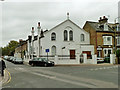
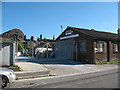
Former Mission Hall
Described as 'Misn Hall' on a 1914 map, 'Marlborough Hall' later, and 'Printing Works' by the 1950s, what is it now? Evidently used, possibly inhabited, but with no noticeable sign or plate.
Image: © Robin Webster
Taken: 30 Oct 2011
0.04 miles
6
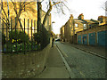
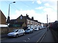
King William Lane
Unlike nearby Lassell Street, the setted surface of this road is not listed, although equally well preserved. A few lock-up garages on the right.
Image: © Stephen Craven
Taken: 6 Apr 2013
0.04 miles

8
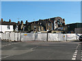
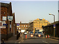
Demolition site on Lassell Street
The plot on the south-west corner of the junction of Lassell Street and Old Woolwich Road, Greenwich, had been demolished in 2010.
I'm not sure what had been there, but the buildings were still present though surrounded in scaffolding in Image taken three months earlier. The demolition gives a glimpse of the backs of properties on Woolwich Road.
Image: © Stephen Craven
Taken: 18 Jul 2010
0.04 miles
9
Greenwich - Lassell Street
Taken from Woodland Crescent.
Image: © Peter Whatley
Taken: 5 Apr 2010
0.04 miles