IMAGES TAKEN NEAR TO
Eastney Street, LONDON, SE10 9NS
Introduction
This page details the photographs taken nearby to Eastney Street, SE10 9NS by members of the Geograph project.
The Geograph project started in 2005 with the aim of publishing, organising and preserving representative images for every square kilometre of Great Britain, Ireland and the Isle of Man.

There are currently over 7.5m images from over14,400 individuals and you can help contribute to the project by visiting https://www.geograph.org.uk
Image Map
Images are licensed for reuse under creativecommons.org/licenses/by-sa/2.0
Notes
- Clicking on the map will re-center to the selected point.
- The higher the marker number, the further away the image location is from the centre of the postcode.
Image Listing (1145 Images Found)
Images are licensed for reuse under creativecommons.org/licenses/by-sa/2.0
Image
Details
Distance
1
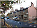
Hardy Cottages, Eastney Street, Greenwich
An attractive terrace of houses, presumably 19th century and named after one of the heroes of Trafalgar http://en.wikipedia.org/wiki/Sir_Thomas_Hardy,_1st_Baronet
Image: © Stephen Craven
Taken: 18 Nov 2011
0.01 miles
2
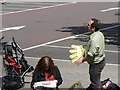
Getting ready to give ?em a big hand
This chap awaits the arrival of the cyclists in the Tour de France so that he can egg them on with his big yellow hand which, I presume, he has brought along especially for the occasion.
Image: © Chris Downer
Taken: 8 Jul 2007
0.01 miles
3
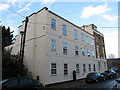
Housing on Eastney Street, Greenwich
This block is immediately adjacent to the former Man in the Moon pub to the right Image
Image: © Stephen Craven
Taken: 18 Nov 2011
0.02 miles
4
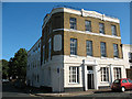
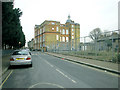
The Man in the Moon, Greenwich
A former pub on the corner of Easthey Street and Old Woolwich Road. The building bears the date 1834 as well as the pub name.
Image: © Stephen Craven
Taken: 18 Jul 2010
0.03 miles
5
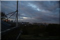
View of Greenwich Power Station and the O2 from the Royal Observatory
Looking north.
Image: © Robert Lamb
Taken: 5 Nov 2016
0.03 miles
6
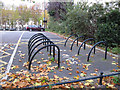
Cycle racks, Eastney Street, Greenwich
In the corner of a car park occupying the space between Park Row and Eastney Street, parking facilities for bicycles (left) and motorcycles (right).
Image: © Stephen Craven
Taken: 18 Nov 2011
0.03 miles
7
Meridian Primary School
The zero meridian passes through the school.
Image: © Dennis Turner
Taken: 5 Feb 2006
0.03 miles
9
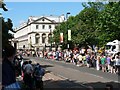
Lining the route in anticipation
As the time approaches for the Tour de France to pass through Greenwich, an enthusiastic crowd gathered along all the route.
Image: © Chris Downer
Taken: 8 Jul 2007
0.03 miles
10
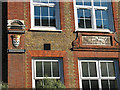
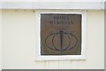
Old plaques on Meridian School
The original name of the school can be seen on these two old plaques: Old Woolwich Road School. According to one, it belonged to the School Board for London (whose SBL monogram can be seen on similar buildings all around the city) and the other to the successor body, London County Council. It is now the Meridian Primary School (being due north of the Royal Observatory) under the control of the London Borough of Greenwich.
Image: © Stephen Craven
Taken: 18 Jul 2010
0.04 miles