IMAGES TAKEN NEAR TO
Hawthorne Crescent, LONDON, SE10 9GS
Introduction
This page details the photographs taken nearby to Hawthorne Crescent, SE10 9GS by members of the Geograph project.
The Geograph project started in 2005 with the aim of publishing, organising and preserving representative images for every square kilometre of Great Britain, Ireland and the Isle of Man.

There are currently over 7.5m images from over14,400 individuals and you can help contribute to the project by visiting https://www.geograph.org.uk
Image Map
Images are licensed for reuse under creativecommons.org/licenses/by-sa/2.0
Notes
- Clicking on the map will re-center to the selected point.
- The higher the marker number, the further away the image location is from the centre of the postcode.
Image Listing (216 Images Found)
Images are licensed for reuse under creativecommons.org/licenses/by-sa/2.0
Image
Details
Distance
1
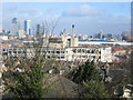
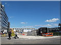
The derelict Greenwich Regional Hospital before demolition
Despite the bulk of the hospital the view is still dominated by Canary Wharf.
Image: © Rachel Bowles
Taken: 28 Mar 2006
0.01 miles
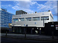
2
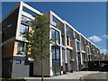
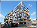
Greenwich Square, block 4
Block 4, consisting of two-storey maisonettes, was among the first part of the site to be occupied.
Image: © Stephen Craven
Taken: 16 May 2015
0.03 miles
3
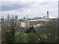
Greenwich Regional Hospital half demolished
As the hospital was dismantled gradually the houses and shops were revealed on Trafalgar Road - and the industry beyond. The horizon is still dominated by Canary and Canada Wharves - and the Dome.
Image: © Rachel Bowles
Taken: 17 Apr 2006
0.03 miles
4
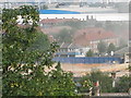
Greenwich Regional Hospital - gone
The last chimney came down with a thunderous bang- and clouds of dust. That was in mid June 2006. The site is still awaiting development, Feb 2007.
Image: © Rachel Bowles
Taken: 18 Jun 2006
0.03 miles
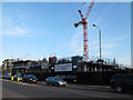
5
Greenwich Square, site for block 3
Block 3 will eventually be built on this site but for now it is a car park for construction workers. The recently completed Block 4 can be seen in the background Image
Image: © Stephen Craven
Taken: 16 May 2015
0.04 miles
6
Greenwich Square, block 2
Block 2, consisting of retail units with apartments above, was among the first part of the site to be occupied.
Image: © Stephen Craven
Taken: 16 May 2015
0.04 miles
7
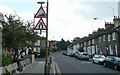
Vanbrugh Hill - Steep Hill 17%
Vanbrugh Hill, Greenwich. 17% steep hill up sign.
Image: © Adam Morse
Taken: 8 Aug 2009
0.06 miles
8
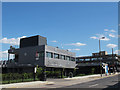
Greenwich Square, marketing suite
They cannot have much more business to do: a look at the developers' website showed that all the completed apartments and nearly all those yet to be built had already been sold; only a few of the yet-to-be-built townhouses in Block 5 (the most expensive on the site) were still available to buy off plan. See also Image
The bus stop in the foreground is on route 386 to Woolwich.
Image: © Stephen Craven
Taken: 16 May 2015
0.06 miles
9
Greenwich Square, marketing suite
Following current practice, the "marketing suite" (or "sales office" as they used to be known) was open long before the new apartments Image were completed. See Image for the hospital that formerly occupied this site.
Image: © Stephen Craven
Taken: 15 Feb 2014
0.07 miles
10
Greenwich Square under construction (2)
Since my previous photo three months earlier of this large construction site Image the development had changed its name from "heart of East Greenwich" (geographically accurate) to Greenwich Square" (probably meant to be more aspirational, sounding as if it is in the town centre, not a mile away).
Image: © Stephen Craven
Taken: 6 Apr 2013
0.07 miles