IMAGES TAKEN NEAR TO
Christchurch Way, LONDON, SE10 9AL
Introduction
This page details the photographs taken nearby to Christchurch Way, SE10 9AL by members of the Geograph project.
The Geograph project started in 2005 with the aim of publishing, organising and preserving representative images for every square kilometre of Great Britain, Ireland and the Isle of Man.

There are currently over 7.5m images from over14,400 individuals and you can help contribute to the project by visiting https://www.geograph.org.uk
Image Map
Images are licensed for reuse under creativecommons.org/licenses/by-sa/2.0
Notes
- Clicking on the map will re-center to the selected point.
- The higher the marker number, the further away the image location is from the centre of the postcode.
Image Listing (360 Images Found)
Images are licensed for reuse under creativecommons.org/licenses/by-sa/2.0
Image
Details
Distance
3
Christ Church, Trafalgar Road, East Greenwich - East end
Image: © John Salmon
Taken: 22 Sep 2010
0.03 miles
4
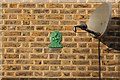
Fire plaque
Insurance plaque on a house in Christchurch Way http://www.geograph.org.uk/photo/1143592
Image: © Richard Croft
Taken: 31 Jan 2009
0.03 miles
5
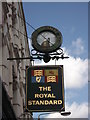
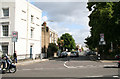
The Royal Standard, pub sign, Greenwich
On the side of Image
Image: © David Anstiss
Taken: 11 Sep 2011
0.03 miles
6
Christ Church, Trafalgar Road, East Greenwich - East end
Image: © John Salmon
Taken: 22 Sep 2010
0.04 miles
8
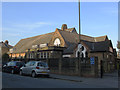
Christ Church hall, Christchurch Way
The hall of the adjacent Christ Church Image
Image: © Stephen Craven
Taken: 6 Apr 2013
0.04 miles
9
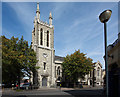
Christ Church, Trafalgar Road, East Greenwich
Image: © John Salmon
Taken: 22 Sep 2010
0.04 miles
10
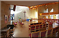
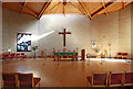
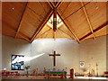
Christ Church, Trafalgar Road, East Greenwich - Interior
Image: © John Salmon
Taken: 22 Sep 2010
0.04 miles