IMAGES TAKEN NEAR TO
St. Marks Close, LONDON, SE10 8TX
Introduction
This page details the photographs taken nearby to St. Marks Close, SE10 8TX by members of the Geograph project.
The Geograph project started in 2005 with the aim of publishing, organising and preserving representative images for every square kilometre of Great Britain, Ireland and the Isle of Man.

There are currently over 7.5m images from over14,400 individuals and you can help contribute to the project by visiting https://www.geograph.org.uk
Image Map
Images are licensed for reuse under creativecommons.org/licenses/by-sa/2.0
Notes
- Clicking on the map will re-center to the selected point.
- The higher the marker number, the further away the image location is from the centre of the postcode.
Image Listing (291 Images Found)
Images are licensed for reuse under creativecommons.org/licenses/by-sa/2.0
Image
Details
Distance
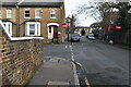
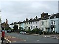
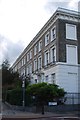
2
Langdale Road
Large Victorian houses with up to twelve chimney pots each.
Image: © Stephen Craven
Taken: 21 Jun 2014
0.03 miles
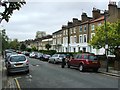
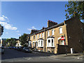
9
Housing on Greenwich South Street (Greenwich Ward 038E)
Image: © Emma R Smith
Taken: 14 Oct 2016
0.04 miles
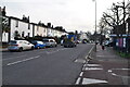
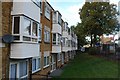
10
Housing on Greenwich South Street (Greenwich Ward 038E)
Image: © Emma R Smith
Taken: 14 Oct 2016
0.04 miles