IMAGES TAKEN NEAR TO
Maidenstone Hill, LONDON, SE10 8SX
Introduction
This page details the photographs taken nearby to Maidenstone Hill, SE10 8SX by members of the Geograph project.
The Geograph project started in 2005 with the aim of publishing, organising and preserving representative images for every square kilometre of Great Britain, Ireland and the Isle of Man.

There are currently over 7.5m images from over14,400 individuals and you can help contribute to the project by visiting https://www.geograph.org.uk
Image Map
Images are licensed for reuse under creativecommons.org/licenses/by-sa/2.0
Notes
- Clicking on the map will re-center to the selected point.
- The higher the marker number, the further away the image location is from the centre of the postcode.
Image Listing (180 Images Found)
Images are licensed for reuse under creativecommons.org/licenses/by-sa/2.0
Image
Details
Distance
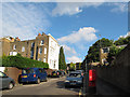
1
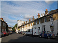
College Place East
A terrace of grade 2 listed houses on Maidenstone Hill dating from 1695 (List Entry number 1210418).
Image: © Stephen Craven
Taken: 20 Jul 2012
0.02 miles
2
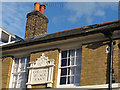
College Place East : name and date
The stone plaque names the terrace; to the right, almost lost behind the downpipe, is a much smaller one "MC 1695". MC is Morden College, a major local landowner. The terrace is grade 2 listed (List Entry number 1210418). See Image for context.
Image: © Stephen Craven
Taken: 20 Jul 2012
0.03 miles
3
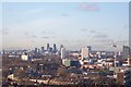
View North west from the Point
Seen from a viewpoint on Point Hill. St Paul's Cathedral is on the left. The 'Gherkin' (see Image for a close-up) and the City of London is in the middle
Image: © David Anstiss
Taken: 27 Nov 2009
0.03 miles
4
Point Hill, Greenwich
Seen at its junction with Maidenstone Hill, as daylight is fading. Canary Wharf is still clear ahead.
Image: © Bill Boaden
Taken: 11 Oct 2014
0.04 miles
5
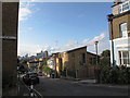
Point Hill, downwards
Looking down Point Hill from its junction with Maidenstone Hill (left). The distant view is of the skyscrapers of Docklands. Compare Image
Image: © Stephen Craven
Taken: 20 Jul 2012
0.04 miles
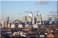
6
View Westwards from The Point
Looking from the viewpoint on Point Hill. The London Eye is in the middle. The BT (Post Office) tower is on the far right (3rd from the right). The Strata Tower http://www.geograph.org.uk/gridref/TQ3278?centi=TQ320788 , is on the left (1st tower from the left). The red-and-white tower just to left of centre in the middle distance is the residential Hawke Tower in Deptford. (See Image) To the right of the crane in the middle is the chimney of Deptford's Waste Transfer Station. The tower on the far right, on the horizon is Guy's Hospital (See Image). The tower in front of that is Mermaid Tower in Evelyn Estate, Deptford (See Image).
Image: © David Anstiss
Taken: 27 Nov 2009
0.04 miles
7
View Northwards from The Point
Looking from the viewpoint on Point Hill, near Blackheath Common. Looking at the Isle of Dogs. The tallest building is Canary Wharf. This and the rest of the other buildings are the new 'financial powerhouse' of London.
Image: © David Anstiss
Taken: 27 Nov 2009
0.04 miles
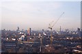
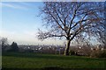
8
View of the River Thames, from the Point
Looking from the viewpoint on Point Hill, near Blackheath Common. Seen across the diverse range of roofs of London.
Image: © David Anstiss
Taken: 27 Nov 2009
0.05 miles
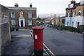
9
Point Hill, upwards
Looking up Point Hill from its junction with Maidenstone Hill. There is a postbox in the foreground. This is the steepest part of the hill with a gradient of approximately 13%. Compare Image
Image: © Stephen Craven
Taken: 20 Jul 2012
0.05 miles
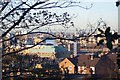
10
The Point, Point Hill
A small green near Point Hill, opposite Point Close. On the edge of the green, are two benches (with extensive views over London) and a metal etched skyline sign showing important features. Beneath are the Blackheath Caverns - former chalk mines (no access).
Image: © David Anstiss
Taken: 27 Nov 2009
0.05 miles