IMAGES TAKEN NEAR TO
Peyton Place, LONDON, SE10 8RS
Introduction
This page details the photographs taken nearby to Peyton Place, SE10 8RS by members of the Geograph project.
The Geograph project started in 2005 with the aim of publishing, organising and preserving representative images for every square kilometre of Great Britain, Ireland and the Isle of Man.

There are currently over 7.5m images from over14,400 individuals and you can help contribute to the project by visiting https://www.geograph.org.uk
Image Map
Images are licensed for reuse under creativecommons.org/licenses/by-sa/2.0
Notes
- Clicking on the map will re-center to the selected point.
- The higher the marker number, the further away the image location is from the centre of the postcode.
Image Listing (491 Images Found)
Images are licensed for reuse under creativecommons.org/licenses/by-sa/2.0
Image
Details
Distance
1
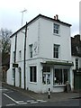
Greenwich Gallery, Peyton Place
According to the "Greenwich Phantom" blogger, this building dates from 1830 and was previously a mortuary, then a school dining room, and now a private art gallery. At the time of my visit it was hosting an exhibition of black-and-white photographs of London life.
Image: © Stephen Craven
Taken: 24 Aug 2014
0.01 miles
2

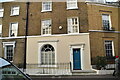
Building behind the Greenwich Gallery
The gallery Image is to the right. This view may disappear as there has been a recent planning application to build houses on the space in the foreground.
Image: © Stephen Craven
Taken: 24 Aug 2014
0.01 miles
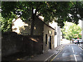
3
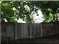
Route of old railway (1)
Looking roughly north from Circus Street, beyond the gates is the route of the branch railway line from Lewisham to Greenwich Park, opened in 1888 and closed in 1917. Surprisingly this section has never been built on, and someone who was with me and pointed it out recalled the rails being in place as recently as the 1960s.
Image: © Stephen Craven
Taken: 20 Jul 2012
0.03 miles
4

Route of former Greenwich Park railway
The railway branch line from Nunhead to Greenwich park was closed in 1917 and never reopened this side of Lewisham. For a fuller history see http://www.disused-stations.org.uk/g/greenwich_park/ . This short stretch (40m) between Circus Street and Royal Hill is one of the few sections that has not yet been built on, although as of 2013 there was a planning application to do so.
Image: © Stephen Craven
Taken: 24 Aug 2014
0.03 miles
6
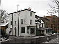
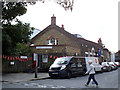
Shops on Royal Hill
As of 2012 this row of shops on the corner of Circus Street included a specialist cheese shop and a butcher. The second building form the left (to the right of the cheese shop) is a grade 2 listed, and on the 2014 Heritage At Risk register, where it is described as an "Early C18 small urban house of central chimneystack plan, the smallest known example of the 1703 Moxon Plan. The building has been vacant for some years and in poor condition. A scheme for restoration and conversion has been agreed but not yet implemented."
Image: © Stephen Craven
Taken: 5 Feb 2012
0.03 miles
7
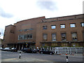
Greenwich Borough Hall
The former town hall, now used by a college Image and various other organisations. On a Sunday it appears to be used by a Christian denomination for worship; they were just coming out as I passed. The building is grade 2 listed (list entry number 1213855).
Image: © Stephen Craven
Taken: 24 Aug 2014
0.03 miles
8
Fishmonger on Circus Street
Away from the other town centre shops, a fishmonger's near the eastern end of Circus Street.
Image: © Stephen Craven
Taken: 20 Jul 2012
0.03 miles