IMAGES TAKEN NEAR TO
Luton Place, LONDON, SE10 8QE
Introduction
This page details the photographs taken nearby to Luton Place, SE10 8QE by members of the Geograph project.
The Geograph project started in 2005 with the aim of publishing, organising and preserving representative images for every square kilometre of Great Britain, Ireland and the Isle of Man.

There are currently over 7.5m images from over14,400 individuals and you can help contribute to the project by visiting https://www.geograph.org.uk
Image Map
Images are licensed for reuse under creativecommons.org/licenses/by-sa/2.0
Notes
- Clicking on the map will re-center to the selected point.
- The higher the marker number, the further away the image location is from the centre of the postcode.
Image Listing (214 Images Found)
Images are licensed for reuse under creativecommons.org/licenses/by-sa/2.0
Image
Details
Distance
1

Former chapel on King George Street
The "Old Chapel" (left) has a datestone of 1879. I have not yet found what denomination it was. The white building to the right is also in the same architectural style.
Image: © Stephen Craven
Taken: 20 Jul 2012
0.04 miles
2
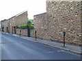
Parking meters, King George Street
The individual parking meter is gradually being replaced by "pay and display" machines. Greenwich retained several of them in 2013.
Image: © Stephen Craven
Taken: 6 May 2013
0.04 miles
3
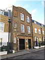
Entrance to former school
There used to be a primary school behind the houses on the north side of King George Street. This entrance bears the date 1898 and the SBL (School Board for London) monogram, as well as entrances for Boys and "Girls and Infants". See Image for the main school building. Compare the entrance to the present college, further along the road Image
Image: © Stephen Craven
Taken: 20 Jul 2012
0.06 miles
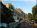
5
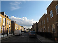
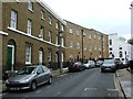
King George Street
King George Street is one of the principal residential streets of West Greenwich, and one of the few that runs level along the hillside rather than up or down. The houses date from the 19th century.
Image: © Stephen Craven
Taken: 20 Jul 2012
0.06 miles
6
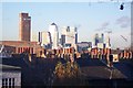
View from Diamond Terrace
Diamond Terrace is a narrow lane from Hyde Vale to Point Hill.
View looks northwards towards Canary Wharf and the Isle of Dogs. The brick tower on the left is the Greenwich School of Management.
Image: © David Anstiss
Taken: 27 Nov 2009
0.07 miles
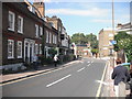
8
Hyde Vale, Greenwich
Looking up the hill.
Image: © Stephen Craven
Taken: 9 Jul 2010
0.07 miles
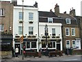
9
Royal Hill, Greenwich
A delightful street, off the tourist trail and home to several remarkable pubs, including the Greenwich Union which brews its own beers and some excellent small shops selling high quality foods.
Image: © Chris Denny
Taken: 16 Aug 2010
0.07 miles
10
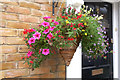
London Flowers (1)
King George Street, Greenwich
Image: © Anthony O'Neil
Taken: 10 Aug 2017
0.08 miles