IMAGES TAKEN NEAR TO
Mumford Mills, Greenwich High Road, LONDON, SE10 8ND
Introduction
This page details the photographs taken nearby to Mumford Mills, Greenwich High Road, SE10 8ND by members of the Geograph project.
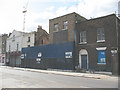
The Geograph project started in 2005 with the aim of publishing, organising and preserving representative images for every square kilometre of Great Britain, Ireland and the Isle of Man.

There are currently over 7.5m images from over14,400 individuals and you can help contribute to the project by visiting https://www.geograph.org.uk
Image Map
Images are licensed for reuse under creativecommons.org/licenses/by-sa/2.0
Notes
- Clicking on the map will re-center to the selected point.
- The higher the marker number, the further away the image location is from the centre of the postcode.
Image Listing (210 Images Found)
Images are licensed for reuse under creativecommons.org/licenses/by-sa/2.0
Image
Details
Distance
1
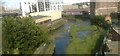
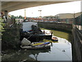
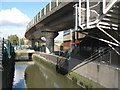
Deptford Creek downstream of Deptford Bridge
Viewed from the Docklands Light Railway train that passes over the creek at this point: the twisting course of the DLR viaduct can be made out on the left.
Image: © Christopher Hilton
Taken: 27 Aug 2015
0.01 miles
2
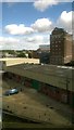
Mumford's flour mill, Deptford Creek
This mill, served by boat along Deptford Creek, was active from the 1840s (replacing an earlier building) to the 1960s. It is seen from the Docklands Light Railway viaduct that twists along the creek here.
For a view of the mill from the other side, and a more detailed history of the building, see Image
Image: © Christopher Hilton
Taken: 27 Aug 2015
0.02 miles
3
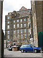
Mumford's Mill, Greenwich
The inscription on the top of the building reads "1790 Mumford's Greenwich Flour Mill" although from various internet references, this building was erected in 1848. Maybe there was an earlier building on the site from 1790?
It was at one time apparently "one of London’s most important flour mills", served by boats sailing up Deptford Creek. The mill was closed in the 1960s.
A detailed history is apparently given in "Remnants of a Revolution: Mumford's Flour Mill, Greenwich", Jonathan Clarke, AIA Industrial Archaeology Review, Volume XXIV 2002.
Image: © Stephen Craven
Taken: 29 Aug 2009
0.02 miles
4
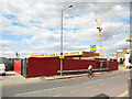
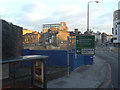
Closed car wash, Greenwich High Road
This former car wash is one of several properties that was vacant and boarded up in 2009, possibly bought by a developer and awaiting better times for building. The solitary cyclist has no need of such facilities anyway!
Image: © Stephen Craven
Taken: 29 Aug 2009
0.04 miles
5
Derelict properties on Greenwich High Road
Given the rapid 'gentrification' of this area it can only be a matter of a few years before this site is occupied by yet another block of 'exclusive' apartments.
Image: © Stephen Craven
Taken: 29 Aug 2009
0.04 miles
8
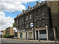
Run-down properties in Greenwich High Road
The ground floor of the building on the corner in this photo is a hair salon, but the two adjacent shops have closed down and at least two of the flats above appeared to be "to let". It may not be long before this block faces the fate of other nearby properties and is demolished to make way for medium- or high-rise apartments.
Image: © Stephen Craven
Taken: 29 Aug 2009
0.06 miles
9
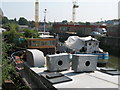
The River Ravensbourne near Deptford Bridge DLR station (3)
Image: © Mike Quinn
Taken: 28 Oct 2008
0.06 miles
10
Demolition site, near Deptford Bridge
A small number of houses and shops have been demolished here, which appear to the left of Stacey Harris's 2010 photo Image I don't yet know what is planned to be built in their place.
Image: © Stephen Craven
Taken: 18 Jan 2015
0.06 miles