IMAGES TAKEN NEAR TO
Primrose Way, LONDON, SE10 8FL
Introduction
This page details the photographs taken nearby to Primrose Way, SE10 8FL by members of the Geograph project.
The Geograph project started in 2005 with the aim of publishing, organising and preserving representative images for every square kilometre of Great Britain, Ireland and the Isle of Man.

There are currently over 7.5m images from over14,400 individuals and you can help contribute to the project by visiting https://www.geograph.org.uk
Image Map
Images are licensed for reuse under creativecommons.org/licenses/by-sa/2.0
Notes
- Clicking on the map will re-center to the selected point.
- The higher the marker number, the further away the image location is from the centre of the postcode.
Image Listing (116 Images Found)
Images are licensed for reuse under creativecommons.org/licenses/by-sa/2.0
Image
Details
Distance
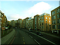
1
Lethbridge Close, SE13
An estate just off Lewisham Road.
Image: © Danny P Robinson
Taken: 17 May 2007
0.02 miles
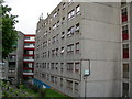
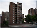
2
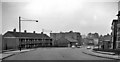
Bottom of Blackheath Hill
A number of modern apartment blocks line the south side of the hill. See Image for a view looking down this part of the hill. Normally this road (the A2) is very busy, but tolerably quiet on a Sunday.
Image: © Stephen Craven
Taken: 18 Jan 2015
0.11 miles
3
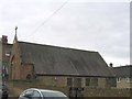
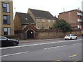
Holy Trinity Centre, Bennett Grove
Church hall belonging to the parish of St John, Deptford. Could be confused historically with the former church of Holy Trinity on Blackheath Hill nearby, which is no longer standing.
Image: © Stephen Craven
Taken: Unknown
0.11 miles
5
Blackheath Hill Station (remains)
Westward view on Blackheath Hill: remains of station (closed 1/1/17) on left side centre; ex-LC&D Nunhead - Greenwich Park branch, closed 1/1/17 but restored Nunhead - Lewisham (with new connection at Lewisham Vale Junction) on 7/7/29.
Image: © Ben Brooksbank
Taken: 25 Mar 1962
0.12 miles
6
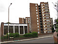
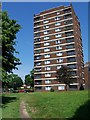
Orchard Community Hall
A community centre on Lewisham Road. The tower block behind is shown in Image
Image: © Stephen Craven
Taken: 9 Jun 2012
0.12 miles
8
Blackheath Hill railway station (site), Greater London
Opened in 1871 by the London Chatham & Dover Railway, later part of the South Eastern & Chatham Railway, on the short branch line from Nunhead to Greenwich Park, this station closed in 1917.
View south west at the forecourt site. The single-storey building fronted the road where the wall now is, between the two blocks of flats. Behind was a cutting with steps down to the platforms.
The area has been redeveloped and no trace remains. For more information, see http://www.disused-stations.org.uk/b/blackheath_hill/index.shtml.
Image: © Nigel Thompson
Taken: 16 Nov 2018
0.13 miles
9
Orchard Estate, Lewisham (2)
Lewisham Road, near Quince Road and the border with Greenwich Borough.
Image: © Danny P Robinson
Taken: 17 May 2007
0.13 miles
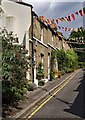
10
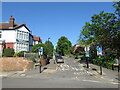
Morden Hill, Lewisham
Morden Hill is a residential road in Lewisham, in south east London.
Road signs indicate that the road is a "no through road" for motor vehicles, but is open to cyclists.
Image: © Malc McDonald
Taken: 8 May 2022
0.13 miles