IMAGES TAKEN NEAR TO
Blackheath Road, LONDON, SE10 8EF
Introduction
This page details the photographs taken nearby to Blackheath Road, SE10 8EF by members of the Geograph project.
The Geograph project started in 2005 with the aim of publishing, organising and preserving representative images for every square kilometre of Great Britain, Ireland and the Isle of Man.

There are currently over 7.5m images from over14,400 individuals and you can help contribute to the project by visiting https://www.geograph.org.uk
Image Map
Images are licensed for reuse under creativecommons.org/licenses/by-sa/2.0
Notes
- Clicking on the map will re-center to the selected point.
- The higher the marker number, the further away the image location is from the centre of the postcode.
Image Listing (175 Images Found)
Images are licensed for reuse under creativecommons.org/licenses/by-sa/2.0
Image
Details
Distance
1
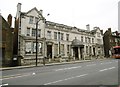
Greenwich Magistrates' Court
On Blackheath Road: https://courttribunalfinder.service.gov.uk/courts/greenwich-magistrates-court
Image: © Mike Faherty
Taken: 28 Mar 2015
0.02 miles
2
Greenwich Magistrates Court
Probably one of the most significant public buildings in the area not to have been photographed for this site before now. It is grade 2 listed (entry number 1272459) and was built in 1909, designed by John Dixon Butler.
Image: © Stephen Craven
Taken: 26 Nov 2013
0.03 miles
3
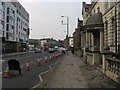
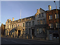
Blackheath Road
Blackheath Road at Greenwich Magistrates Court
Image: © Shaun Ferguson
Taken: 24 Oct 2012
0.04 miles
4
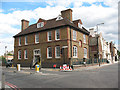
Former school building, Greenwich High Road
The building bears the monogram of the SBL (School Board for London) and is on the corner of Greenwich High Road (to the left in this photo) and Blackheath Road. I had originally mistaken it for the Magistrates Court Image
Image: © Stephen Craven
Taken: 29 Aug 2009
0.05 miles
5

Maurice Drummond House, Greenwich
This block on Catherine Grove, West Greenwich, was formerly a residential block for Metropolitan Police officers but was vacant and becoming derelict at the time it was photographed from Greenwich High Road to the west.
Image: © Stephen Craven
Taken: 29 Aug 2009
0.06 miles
6
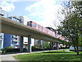
Docklands Light Railway at Deptford
Docklands Light Railway approaching Deptford Bridge station. This section of route opened in 1999.
Image: © Malc McDonald
Taken: 3 May 2010
0.07 miles
7
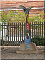
Sustrans milepost at Deptford Bridge
The milepost is under a DLR viaduct Image It marks 1 mile from Greenwich, the start of the Waterlink Way (National Cycle Network route 21).
Image: © Stephen Craven
Taken: 19 Sep 2009
0.07 miles
8
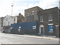
Derelict properties on Greenwich High Road
Given the rapid 'gentrification' of this area it can only be a matter of a few years before this site is occupied by yet another block of 'exclusive' apartments.
Image: © Stephen Craven
Taken: 29 Aug 2009
0.07 miles
10
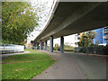
Cycle path under the DLR viaduct
Cycle Route 21 (Waterlink Way) approaching Deptford Bridge runs underneath the Docklands Light Railway viaduct for a short distance. The viaduct is seen from the side in Image
Image: © Stephen Craven
Taken: 19 Sep 2009
0.08 miles