IMAGES TAKEN NEAR TO
Crosslet Vale, LONDON, SE10 8DJ
Introduction
This page details the photographs taken nearby to Crosslet Vale, SE10 8DJ by members of the Geograph project.
The Geograph project started in 2005 with the aim of publishing, organising and preserving representative images for every square kilometre of Great Britain, Ireland and the Isle of Man.

There are currently over 7.5m images from over14,400 individuals and you can help contribute to the project by visiting https://www.geograph.org.uk
Image Map
Images are licensed for reuse under creativecommons.org/licenses/by-sa/2.0
Notes
- Clicking on the map will re-center to the selected point.
- The higher the marker number, the further away the image location is from the centre of the postcode.
Image Listing (177 Images Found)
Images are licensed for reuse under creativecommons.org/licenses/by-sa/2.0
Image
Details
Distance
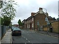
1
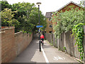
Cycle path to John Penn Street
A view from the Blackheath Road end of the path.
Image: © Stephen Craven
Taken: 9 Jun 2012
0.05 miles
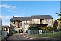
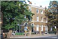
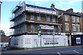
4
Housing in John Penn Street (Greenwich Ward 038A)
Image: © Emma R Smith
Taken: 14 Oct 2016
0.06 miles
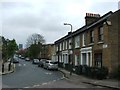
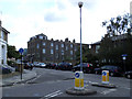
6
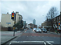
Blackheath Road, Greenwich
Looking towards Deptford
Image: © David Howard
Taken: 30 Dec 2012
0.06 miles
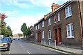
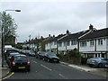
7
Housing on Blackheath Road (Greenwich Ward 038D)
Image: © Emma R Smith
Taken: 14 Oct 2016
0.08 miles
9
Housing on Blackheath Road (Greenwich Ward 038D)
Image: © Emma R Smith
Taken: 14 Oct 2016
0.10 miles
10
Cycle shortcut
A short cycle lane on the pavement cuts off a few metres for cyclists turning left from Guildford Grove into Egerton Drive. It seems a bit pointless.
Image: © Stephen Craven
Taken: 21 Jun 2014
0.10 miles