IMAGES TAKEN NEAR TO
Greenwich High Road, LONDON, SE10 8BH
Introduction
This page details the photographs taken nearby to Greenwich High Road, SE10 8BH by members of the Geograph project.
The Geograph project started in 2005 with the aim of publishing, organising and preserving representative images for every square kilometre of Great Britain, Ireland and the Isle of Man.

There are currently over 7.5m images from over14,400 individuals and you can help contribute to the project by visiting https://www.geograph.org.uk
Image Map
Images are licensed for reuse under creativecommons.org/licenses/by-sa/2.0
Notes
- Clicking on the map will re-center to the selected point.
- The higher the marker number, the further away the image location is from the centre of the postcode.
Image Listing (913 Images Found)
Images are licensed for reuse under creativecommons.org/licenses/by-sa/2.0
Image
Details
Distance
1
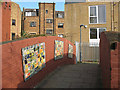
Railway footbridge in Greenwich
This arched brick footbridge on a footpath linking Straightsmouth and Greenwich High Road is probably contemporary with the railway beneath it (1878).
For a view along the railway either side of the bridge see Image and Image
Image: © Stephen Craven
Taken: 24 Apr 2010
0.01 miles
2
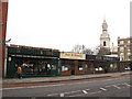
Shops on Greenwich High Road (1)
These shops, at the end of 2012, comprised a cafe, hair salon and barbers. St Alfege church spire in the background.
Image: © Stephen Craven
Taken: 26 Dec 2012
0.02 miles
3
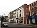
Shops on Greenwich High Road (2)
These shops, at the end of 2012, comprised a bookshop, bank branch and post office. The building nearest the camera had been a medical surgery but was to let.
Image: © Stephen Craven
Taken: 26 Dec 2012
0.02 miles
5
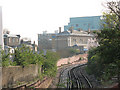
Railway approaching Greenwich
This is the line as it rises up from passing under Greenwich Church Street Image and curves right into Greenwich Station Image The classical station building can be seen beyond, with the Novotel in the background.
Image: © Stephen Craven
Taken: 24 Apr 2010
0.03 miles
6
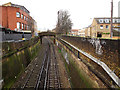
Railway through Greenwich town centre
Viewed looking west from Greenwich High Road. For a view beyond footbridge in this picture, see Image
Image: © Stephen Craven
Taken: 26 Dec 2012
0.03 miles
7
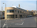
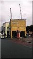
New building on Straightsmouth
A recent building on the north side of Straightsmouth on the corner of Churchfields. It looks more likely to be offices than housing but I have not managed to find the name of the business.
Image: © Stephen Craven
Taken: 24 Apr 2010
0.03 miles
8
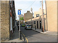
Churchfields, Greenwich
A short and narrow street with a short name. The tower of St Alfege's church in the background gives a clue to the origins of the name.
Image: © Stephen Craven
Taken: 24 Apr 2010
0.03 miles
9
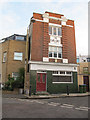
The Earl Grey, Greenwich
I presume this building on Churchfields is a closed pub, but now appears to be a private house. The date on it is 1913.
Image: © Stephen Craven
Taken: 10 Dec 2011
0.04 miles
